
ચિત્ર:Nazi Germany.png

આ પૂર્વાવલોકનનું કદ: ૭૭૨ × ૬૦૦ પિક્સેલ. અન્ય આવર્તનો: ૩૦૯ × ૨૪૦ પિક્સેલ | ૬૧૮ × ૪૮૦ પિક્સેલ | ૯૮૯ × ૭૬૮ પિક્સેલ | ૧,૨૦૦ × ૯૩૨ પિક્સેલ.
મૂળભુત ફાઇલ (૧,૨૦૦ × ૯૩૨ પીક્સલ, ફાઇલનું કદ: ૨૬૩ KB, MIME પ્રકાર: image/png)

|
File:Nazi Germany.svg is a vector version of this file. It should be used in place of this PNG file when not inferior.
File:Nazi Germany.png → File:Nazi Germany.svg
For more information, see Help:SVG. |
 |
સારાંશ:
| વર્ણન |
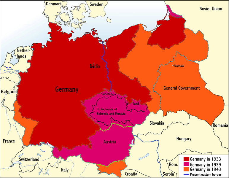
English: An overview map of Nazi Germany to 1943. |
||||||||
| તારીખ | |||||||||
| સ્રોત | Transferred from the English Wikipedia. Original file is/was here. (Original upload log available below.) | ||||||||
| લેખક | Wikinist | ||||||||
| પરવાનગી (આ ફાઈલનો ફરી ઉપયોગ) |
|
||||||||
| અન્ય આવૃત્તિઓ |
Derivative works of this file: Nazi Germany-it.svg |


અસલ - મૂળ અપલોડનો લોગ
All the following user names refer to the English Wikipedia.
| Date/Time | Dimensions | User | Comment |
|---|---|---|---|
| 00:03, 24 June 2008 | 1,200×932 (275 KB) |
Wikinist | (Belgia -> Belgium) |
| 00:52, 30 April 2008 | 1,200×932 (286 KB) |
R-41 | (Removed swastika from map. The title "Germany" is moved up to the centre of Germany on the map now.) |
| 21:37, 29 April 2008 | 1,200×932 (291 KB) |
Wikinist | (== Description== {{Information |Description=An overview map of Nazi Germany, based on another map[http://en.wikipedia.org/wiki/Image:GDR.png] by [[:de:Benutzer:kgberger|kgberger]]. Placenames replaced with English ones, resolution decreased, a lot of info) |
ફાઇલનો ઇતિહાસ
તારીખ/સમય ઉપર ક્લિક કરવાથી તે સમયે ફાઇલ કેવી હતી તે જોવા મળશે.
| તારીખ/સમય | લઘુચિત્ર | પરિમાણો | સભ્ય | ટિપ્પણી | |
|---|---|---|---|---|---|
| વર્તમાન | ૦૫:૦૫, ૭ જૂન ૨૦૦૯ | | ૧,૨૦૦ × ૯૩૨ (૨૬૩ KB) | MaggotMaster | Reverted to version as of 22:18, 21 May 2009 |
| ૧૭:૨૭, ૪ જૂન ૨૦૦૯ |  | ૧,૨૦૦ × ૯૩૨ (૨૩૪ KB) | Fz22~commonswiki | {{Information |Description= |Source= |Date= |Author= |Permission= |other_versions= }} | |
| ૦૩:૪૮, ૨૨ મે ૨૦૦૯ |  | ૧,૨૦૦ × ૯૩૨ (૨૬૩ KB) | Hohum | Reduced garish colour intensity. | |
| ૧૫:૦૦, ૧૯ જાન્યુઆરી ૨૦૦૯ |  | ૧,૨૦૦ × ૯૩૨ (૨૦૭ KB) | Brianski | clean up the legend | |
| ૦૧:૫૦, ૯ ઓક્ટોબર ૨૦૦૮ |  | ૧,૨૦૦ × ૯૩૨ (૨૭૫ KB) | File Upload Bot (Magnus Manske) | {{BotMoveToCommons|en.wikipedia}} {{Information |Description={{en|An overview map of Nazi Germany, based on another map (en::Image:GDR.png) by kgberger. Placenames replaced with English ones, resolution decreased, a lot |
ફાઇલનો વપરાશ
આ ફાઇલને કોઇ પાનાં વાપરતા નથી.
ફાઇલનો વ્યાપક ઉપયોગ
નીચેની બીજી વિકિઓ આ ફાઈલ વાપરે છે:
- la.wikipedia.org પર વપરાશ
- pt.wikipedia.org પર વપરાશ