લખાણ પર જાઓ

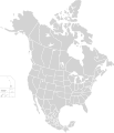
ચિત્ર:North America second level political division 2.svg

Page contents not supported in other languages.
વિકિપીડિયામાંથી

મૂળભુત ફાઇલ(SVG ફાઇલ, માત્ર ૫૧૨ × ૫૯૬ પીક્સલ, ફાઇલનું કદ: ૧૩૨ KB)

આ ફાઇલ Wikimedia Commonsનો ભાગ છે અને શક્ય છે કે અન્ય પ્રકલ્પોમાં પણ વપરાઇ હોય. ત્યાંનાં મૂળ ફાઇલનાં વર્ણનનાં પાના પર આપેલું વર્ણન નીચે દર્શાવેલું છે.

સારાંશ:

વર્ણન
English: Map of North America and its second-level political divisions. Canadian provinces, US and Mexican states. Canada, Mexico, United States.

Non-contiguous parts of a states/provinces are "grouped" together with the main area of the state/provinces, so any state/provinces can be coloured in completion with one click anywhere on the state/provinces's area.

Also, all states/provinces have a "id" attached to them, making them easy to find. Select "find" and then enter in the state/provinces's ISO 3166-2 code in the "id" field to find it. The codes can be found here (Canada), here (USA) and here (Mexico).
તારીખ
સ્રોત

Canada and US map: BlankMap-USA-states-Canada-provinces, HI closer.svg by Lokal_Profil.
Mexico map: Mexico template.svg by Mario Fuente Cid
Combined by Alex Covarrubias.

 
The SVG code is valid.
 
This vector image was created with Inkscape, and then manually edited
.
 
W3C-validity not checked.
લેખક Alex Covarrubias
પરવાનગી
(આ ફાઈલનો ફરી ઉપયોગ)
w:en:Creative Commons
આરોપણ શેર- અલાઈક (બિન ભેદભાવ વહેંચણી)
આ ફાઈલ વપરાશની પરવાનગી : Creative Commons Attribution-Share Alike 2.5 Generic license.
તમે મુક્ત છો:
  • વહેંચવા – નકલ કરવા, વિતરણ કરવા અને રચનાઓ મોકલવા
  • રીમિક્સ કરવા કે મઠારવા – રચના અપનાવવા
નીચેની શરત હેઠળ:
  • આરોપણ – તમારે આ રચનાનો ઉપયોગ કરવા માટે લેખક કે પ્રકાશન અધિકાર ધારકની યોગ્ય માહિતી, પરવાનગી ‍(‌લાયસન્સ)ની કડી અને તેમાં ફેરફાર કર્યો હોય તો તેનો ઉલ્લેખ કરવો જ પડશે. તમે આ સત્તા અનુસાર જ આ રચનાનો પ્રયોગ થવો જોઈએ, પણ તેઓ તમને અથવા તમારા ઉપયોગ સાથે સંમત થાય છે તે રીતે નહીં.
  • શેર- અલાઈક (બિન ભેદભાવ વહેંચણી) – તમે જો આ રચનાને બદલશો, તેમાં ફેરફાર કરશો અથવા તેના પર આધારિત કોઇ કાર્ય બનાવશો તો તમારે પરિણામી કાર્યને તે જ અથવા અનુરૂપ પરવાનગી હેઠળ જ પ્રકાશિત કરવું પડશે.
અન્ય આવૃત્તિઓ

Derivative works of this file:

Captions

Add a one-line explanation of what this file represents

Items portrayed in this file

દર્શાવે છે

ફાઇલનો ઇતિહાસ

તારીખ/સમય ઉપર ક્લિક કરવાથી તે સમયે ફાઇલ કેવી હતી તે જોવા મળશે.

તારીખ/સમયલઘુચિત્રપરિમાણોસભ્યટિપ્પણી
વર્તમાન૦૭:૨૧, ૨૩ નવેમ્બર ૨૦૨૦૦૭:૨૧, ૨૩ નવેમ્બર ૨૦૨૦નું લઘુચિત્ર સંસ્કરણ૫૧૨ × ૫૯૬ (૧૩૨ KB)Ponderosapine210Added the prominent islands of Manitoulin (Ontario) and Isle Royale (Michigan) to the Great Lakes.
૦૪:૩૭, ૨ જૂન ૨૦૧૯૦૪:૩૭, ૨ જૂન ૨૦૧૯નું લઘુચિત્ર સંસ્કરણ૫૧૨ × ૫૯૬ (૧૩૦ KB)Fluffy89502added territories, made DC visible, adjusted mexican borders
૧૭:૫૩, ૪ એપ્રિલ ૨૦૧૪૧૭:૫૩, ૪ એપ્રિલ ૨૦૧૪નું લઘુચિત્ર સંસ્કરણ૧,૭૧૨ × ૧,૯૯૨ (૨૭૦ KB)Lommesmade the borders between the mexican subdivisions the same size as their canadian / us counterparts.
૦૪:૫૩, ૯ ડિસેમ્બર ૨૦૦૭૦૪:૫૩, ૯ ડિસેમ્બર ૨૦૦૭નું લઘુચિત્ર સંસ્કરણ૧,૭૧૨ × ૧,૯૯૨ (૩૨૭ KB)Lokal ProfilCode cleanup
૧૩:૨૫, ૭ ઓક્ટોબર ૨૦૦૭૧૩:૨૫, ૭ ઓક્ટોબર ૨૦૦૭નું લઘુચિત્ર સંસ્કરણ૧,૭૧૨ × ૧,૯૯૨ (૩૪૨ KB)AlexCovarrubias== Summary == {{Information |Description=Map of North America and its second-level political divisions. Canadian provinces, US and Mexican states. Canada, Mexico, United States. |Source=Canada and US map by Alan Rockefeller. Mexico map by Alex Covarrubias

આ ફાઇલને કોઇ પાનાં વાપરતા નથી.

ફાઇલનો વ્યાપક ઉપયોગ

મૅટાડેટા