
ચિત્ર:Northern icesheet-fr.png

આ પૂર્વાવલોકનનું કદ: ૮૦૦ × ૫૮૭ પિક્સેલ. અન્ય આવર્તનો: ૩૨૦ × ૨૩૫ પિક્સેલ | ૬૪૦ × ૪૬૯ પિક્સેલ | ૧,૦૨૪ × ૭૫૧ પિક્સેલ | ૧,૨૮૦ × ૯૩૯ પિક્સેલ | ૨,૨૩૬ × ૧,૬૪૦ પિક્સેલ.
મૂળભુત ફાઇલ (૨,૨૩૬ × ૧,૬૪૦ પીક્સલ, ફાઇલનું કદ: ૪૦૨ KB, MIME પ્રકાર: image/png)
સારાંશ:
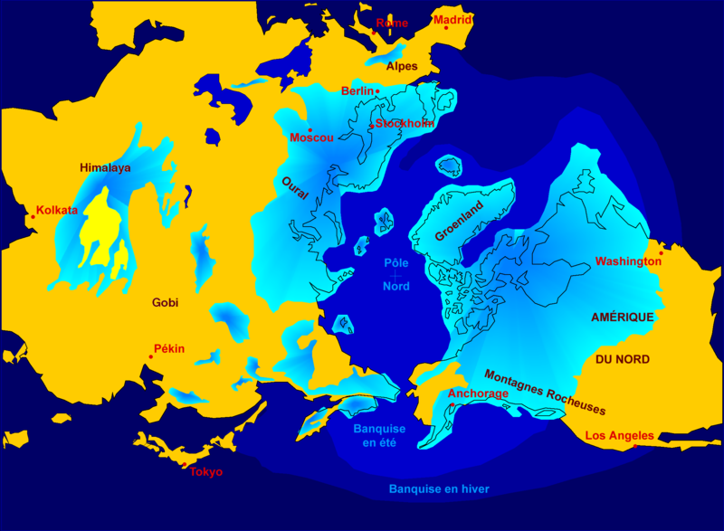
| વર્ણન | Northern hemisphere glaciation during the last ice ages. The set up of 3 to 4 km thick ice sheets caused a sea level lowering of about 120 m. Also the Alps and the Himalaya were covered by glaciers. The limit of winter sea ice coverage was much more to the south. |
| તારીખ | 2000-04-07, modified October 2006 |
| સ્રોત | Image:Northern_icesheet_hg.png created by Hannes Grobe |
| લેખક | Hannes Grobe 23:06, 21 July 2006 (UTC), Alfred Wegener Institute for Polar and Marine Research, Bremerhaven, Germany, translated by Sting |
| પરવાનગી (આ ફાઈલનો ફરી ઉપયોગ) |
share alike, attribution required (Creative Commons CC-BY-SA-2.5) |
| અન્ય આવૃત્તિઓ |
in English : Image:Northern_icesheet_hg.png USGS map |
Français : * Sujet : Carte de l'hémisphère nord durant la dernière glaciation. Une couche de glace de 3 à 4 km d'épaisseur a entraîné un abaissement du niveau de la mer d'environ 120 m. Les Alpes et l'Himalaya étaient recouverts par des glaciers. L'extension de la banquise en hiver allait bien plus au Sud qu'actuellement ;
- Source : Image:Northern_icesheet_hg.png créée par Hannes Grobe ;
- Auteur : Hannes Grobe, cette version par fr:Sting ;
- Date : Avril 2000, modifications : octobre 2006 ;
- Version originale anglophone : Image:Northern_icesheet_hg.png ;
- Version alternative : carte USGS (lien externe).
પરવાના
આ ફાઈલ વપરાશની પરવાનગી : Creative Commons Attribution-Share Alike 2.5 Generic license.
- તમે મુક્ત છો:
- વહેંચવા – નકલ કરવા, વિતરણ કરવા અને રચનાઓ મોકલવા
- રીમિક્સ કરવા કે મઠારવા – રચના અપનાવવા
- નીચેની શરત હેઠળ:
- આરોપણ – તમારે આ રચનાનો ઉપયોગ કરવા માટે લેખક કે પ્રકાશન અધિકાર ધારકની યોગ્ય માહિતી, પરવાનગી (લાયસન્સ)ની કડી અને તેમાં ફેરફાર કર્યો હોય તો તેનો ઉલ્લેખ કરવો જ પડશે. તમે આ સત્તા અનુસાર જ આ રચનાનો પ્રયોગ થવો જોઈએ, પણ તેઓ તમને અથવા તમારા ઉપયોગ સાથે સંમત થાય છે તે રીતે નહીં.
- શેર- અલાઈક (બિન ભેદભાવ વહેંચણી) – તમે જો આ રચનાને બદલશો, તેમાં ફેરફાર કરશો અથવા તેના પર આધારિત કોઇ કાર્ય બનાવશો તો તમારે પરિણામી કાર્યને તે જ અથવા અનુરૂપ પરવાનગી હેઠળ જ પ્રકાશિત કરવું પડશે.
ફાઇલનો ઇતિહાસ
તારીખ/સમય ઉપર ક્લિક કરવાથી તે સમયે ફાઇલ કેવી હતી તે જોવા મળશે.
| તારીખ/સમય | લઘુચિત્ર | પરિમાણો | સભ્ય | ટિપ્પણી | |
|---|---|---|---|---|---|
| વર્તમાન | ૦૦:૪૬, ૨૩ ઓક્ટોબર ૨૦૦૬ | | ૨,૨૩૬ × ૧,૬૪૦ (૪૦૨ KB) | Sting | {{Information| |Description=Northern hemisphere glaciation during the last ice ages. The set up of 3 to 4 km thick ice sheets caused a sea level lowering of about 120 m. Also the Alps and the Himalya were covered by glaciers. The limit of winter sea ice c |
ફાઇલનો વપરાશ
આ ફાઇલને કોઇ પાનાં વાપરતા નથી.
ફાઇલનો વ્યાપક ઉપયોગ
નીચેની બીજી વિકિઓ આ ફાઈલ વાપરે છે:
- ast.wikipedia.org પર વપરાશ
- az.wikipedia.org પર વપરાશ
- de.wikipedia.org પર વપરાશ
- fr.wikipedia.org પર વપરાશ
- Pléistocène
- Glaciation
- Inlandsis
- Géographie de la Colombie-Britannique
- Histoire de l'humanité
- Wikipédia:Atelier graphique/Images à améliorer/Archives/Novembre 2006
- Archipel finlandais
- Portail:Paléontologie
- Wikipédia:Sélection/Paléontologie (période géologique)
- Wikipédia:Lumière sur/Pléistocène
- Wikipédia:Oracle/semaine 48 2011
- Utilisateur:Orbitale/Brouillon Dernière période glaciaire
- Dernière période glaciaire
- Climat de l'Arctique
- Liste de sites et cultures archéologiques en Sibérie
- gl.wikipedia.org પર વપરાશ
- ko.wikipedia.org પર વપરાશ
- www.wikidata.org પર વપરાશ