
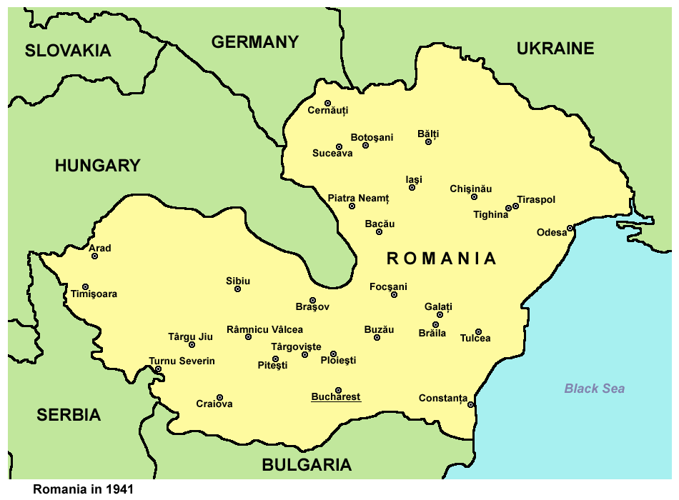
ચિત્ર:Romania1941.png
આ પૂર્વાવલોકનનું કદ: ૮૦૦ × ૫૮૯ પિક્સેલ. અન્ય આવર્તનો: ૩૨૦ × ૨૩૬ પિક્સેલ | ૬૪૦ × ૪૭૨ પિક્સેલ | ૯૫૦ × ૭૦૦ પિક્સેલ.
મૂળભુત ફાઇલ (૯૫૦ × ૭૦૦ પીક્સલ, ફાઇલનું કદ: ૬૦ KB, MIME પ્રકાર: image/png)
સારાંશ:
| વર્ણન | Historic map of Romania in 1941. |
| તારીખ | ૨૮ ડિસેમ્બર ૨૦૦૬ (original upload date) |
| સ્રોત | પોતાની રચના |
| લેખક | PANONIAN |
Source and license

|
This map has been uploaded by Electionworld from en.wikipedia.org to enable the |
self made map by user:PANONIAN
પરવાના
| હું, આ રચનાઓ પ્રકાશન અધિકાર ધારક, આ રચનાને public domain પર પ્રકાશિત કરું છું. આ સમગ્ર વિશ્વમઆં કાર્યરત રહેશે. અમુક દેશોમાં કાયદેસર રીતે તે શક્ય નથી, જો તેમ હોય તો : કો કોઈને પણ કોઈપણ વપરાશ, કોઇ પણ શરત વગર, માટે આ રચના વાપરવાની છૂટ આપું છું સિવાયકે તે શરતો કાયદેસર જરૂરી હોય. |
References
- http://upload.moldova.org/politicom/Transnistria/transnistria_holocaust.gif
- http://kehilalinks.jewishgen.org/sokiryany/1942Romania.gif
- http://academic.evergreen.edu/g/grossmaz/20thCentRomania.jpg
- http://www.ushmm.org/lcmedia/map/lc/image/rom69090.gif
- http://www.ushmm.org/lcmedia/map/lc/image/rom19020.gif
- http://www.ushmm.org/lcmedia/map/lc/image/rom73160.gif
- http://www.freewebs.com/networksromania/_45403710_romania_1942_2009_466.gif
- http://4.bp.blogspot.com/-q2BmrHGgWQ4/Tnr7eEPaGsI/AAAAAAAAAIw/tnEOeauMgMU/s1600/Romania+1941-1944.jpg
- http://www.zum.de/whkmla/histatlas/balkans/rum1941s.gif
ફાઇલનો ઇતિહાસ
તારીખ/સમય ઉપર ક્લિક કરવાથી તે સમયે ફાઇલ કેવી હતી તે જોવા મળશે.
| તારીખ/સમય | લઘુચિત્ર | પરિમાણો | સભ્ય | ટિપ્પણી | |
|---|---|---|---|---|---|
| વર્તમાન | ૧૯:૦૦, ૨૯ સપ્ટેમ્બર ૨૦૧૨ | | ૯૫૦ × ૭૦૦ (૬૦ KB) | PANONIAN | improved version |
| ૦૦:૨૧, ૨૯ ડિસેમ્બર ૨૦૦૬ |  | ૩૫૯ × ૨૫૩ (૧૩ KB) | Electionworld | {{ew|en|PANONIAN}} historic map of Romania (self made) {{PD-self}} Category:Maps of the history of Romania Category:Maps of World War II in Europe |
ફાઇલનો વપરાશ
આ ફાઇલ માં નીચેનું પાનું વપરાયેલું છે:
ફાઇલનો વ્યાપક ઉપયોગ
નીચેની બીજી વિકિઓ આ ફાઈલ વાપરે છે:
- af.wikipedia.org પર વપરાશ
- ba.wikipedia.org પર વપરાશ
- be-tarask.wikipedia.org પર વપરાશ
- be.wikipedia.org પર વપરાશ
- bg.wikipedia.org પર વપરાશ
- bs.wikipedia.org પર વપરાશ
- ca.wikipedia.org પર વપરાશ
- cs.wikipedia.org પર વપરાશ
- cv.wikipedia.org પર વપરાશ
- de.wikipedia.org પર વપરાશ
- el.wikipedia.org પર વપરાશ
- en.wikipedia.org પર વપરાશ
- eo.wikipedia.org પર વપરાશ
- eu.wikipedia.org પર વપરાશ
- fi.wikipedia.org પર વપરાશ
- fo.wikipedia.org પર વપરાશ
- gl.wikipedia.org પર વપરાશ
- he.wikipedia.org પર વપરાશ
- hi.wikipedia.org પર વપરાશ
- hr.wikipedia.org પર વપરાશ
- hu.wikipedia.org પર વપરાશ
- hy.wikipedia.org પર વપરાશ
- hyw.wikipedia.org પર વપરાશ
- id.wikipedia.org પર વપરાશ
- incubator.wikimedia.org પર વપરાશ
- is.wikipedia.org પર વપરાશ
- it.wikipedia.org પર વપરાશ
- ja.wikipedia.org પર વપરાશ
- jv.wikipedia.org પર વપરાશ
- ko.wikipedia.org પર વપરાશ
- lt.wikipedia.org પર વપરાશ
- lv.wikipedia.org પર વપરાશ
- mk.wikipedia.org પર વપરાશ
આ ફાઇલના વધુ વૈશ્વિક વપરાશ જુઓ.