
ચિત્ર:Tularosa-Basin-NM-USGS-map opaque.gif
આ પૂર્વાવલોકનનું કદ: ૪૪૭ × ૫૯૯ પિક્સેલ. અન્ય આવર્તનો: ૧૭૯ × ૨૪૦ પિક્સેલ | ૬૨૪ × ૮૩૬ પિક્સેલ.
મૂળભુત ફાઇલ (૬૨૪ × ૮૩૬ પીક્સલ, ફાઇલનું કદ: ૫૯ KB, MIME પ્રકાર: image/gif)
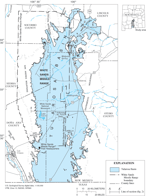
| વર્ણન | Location map of Tularosa Basin 2004. Huff, Glenn F. (2005) "Simulation of Ground-Water Flow in the Basin-Fill Aquifer of the Tularosa Basin, South-Central New Mexico, Predevelopment through 2040" Scientific Investigations Report 2004-5197, United States Geological Survey, Washongton, D.C., fig. 1. | |||
| તારીખ | ||||
| સ્રોત |
USGS (https://pubs.er.usgs.gov/usgspubs/sir/sir20045197) http://pubs.usgs.gov/sir/2004/5197/ http://pubs.usgs.gov/sir/2004/5197/images/fig1.gif |
|||
| લેખક | Huff, Glenn F. (United States Geological Survey) | |||
| પરવાનગી (આ ફાઈલનો ફરી ઉપયોગ) |
|
|||
| અન્ય આવૃત્તિઓ | Image:Tularosa-Basin-NM-USGS-map.gif (transparent version) |
ફાઇલનો ઇતિહાસ
તારીખ/સમય ઉપર ક્લિક કરવાથી તે સમયે ફાઇલ કેવી હતી તે જોવા મળશે.
| તારીખ/સમય | લઘુચિત્ર | પરિમાણો | સભ્ય | ટિપ્પણી | |
|---|---|---|---|---|---|
| વર્તમાન | ૧૮:૨૦, ૧૧ ડિસેમ્બર ૨૦૦૭ | | ૬૨૪ × ૮૩૬ (૫૯ KB) | AnonMoos | actual opaque version |
| ૧૧:૨૫, ૭ ઓક્ટોબર ૨૦૦૭ |  | ૬૨૪ × ૮૩૬ (૬૧ KB) | Balmung0731 | {{Information |Description=Location map of Tularosa Basin 2004. Huff, Glenn F. (2005) "Simulation of Ground-Water Flow in the Basin-Fill Aquifer of the Tularosa Basin, South-Central New Mexico, Predevelopment through 2040" Scientific Investigations Report |
ફાઇલનો વપરાશ
આ ફાઇલને કોઇ પાનાં વાપરતા નથી.
ફાઇલનો વ્યાપક ઉપયોગ
નીચેની બીજી વિકિઓ આ ફાઈલ વાપરે છે:
- bg.wikipedia.org પર વપરાશ
- en.wikipedia.org પર વપરાશ
- fa.wikipedia.org પર વપરાશ
- fr.wikipedia.org પર વપરાશ
- he.wikipedia.org પર વપરાશ
- hu.wikipedia.org પર વપરાશ
- ko.wikipedia.org પર વપરાશ
- ru.wikipedia.org પર વપરાશ
- sv.wikipedia.org પર વપરાશ
- uk.wikipedia.org પર વપરાશ
- vi.wikipedia.org પર વપરાશ
- www.wikidata.org પર વપરાશ
- zh.wikipedia.org પર વપરાશ