
ચિત્ર:Uruguayrivermap.png
આ પૂર્વાવલોકનનું કદ: ૫૯૫ × ૫૯૯ પિક્સેલ. અન્ય આવર્તનો: ૨૩૮ × ૨૪૦ પિક્સેલ | ૪૭૭ × ૪૮૦ પિક્સેલ | ૧,૦૦૦ × ૧,૦૦૭ પિક્સેલ.
મૂળભુત ફાઇલ (૧,૦૦૦ × ૧,૦૦૭ પીક્સલ, ફાઇલનું કદ: ૨૧૭ KB, MIME પ્રકાર: image/png)
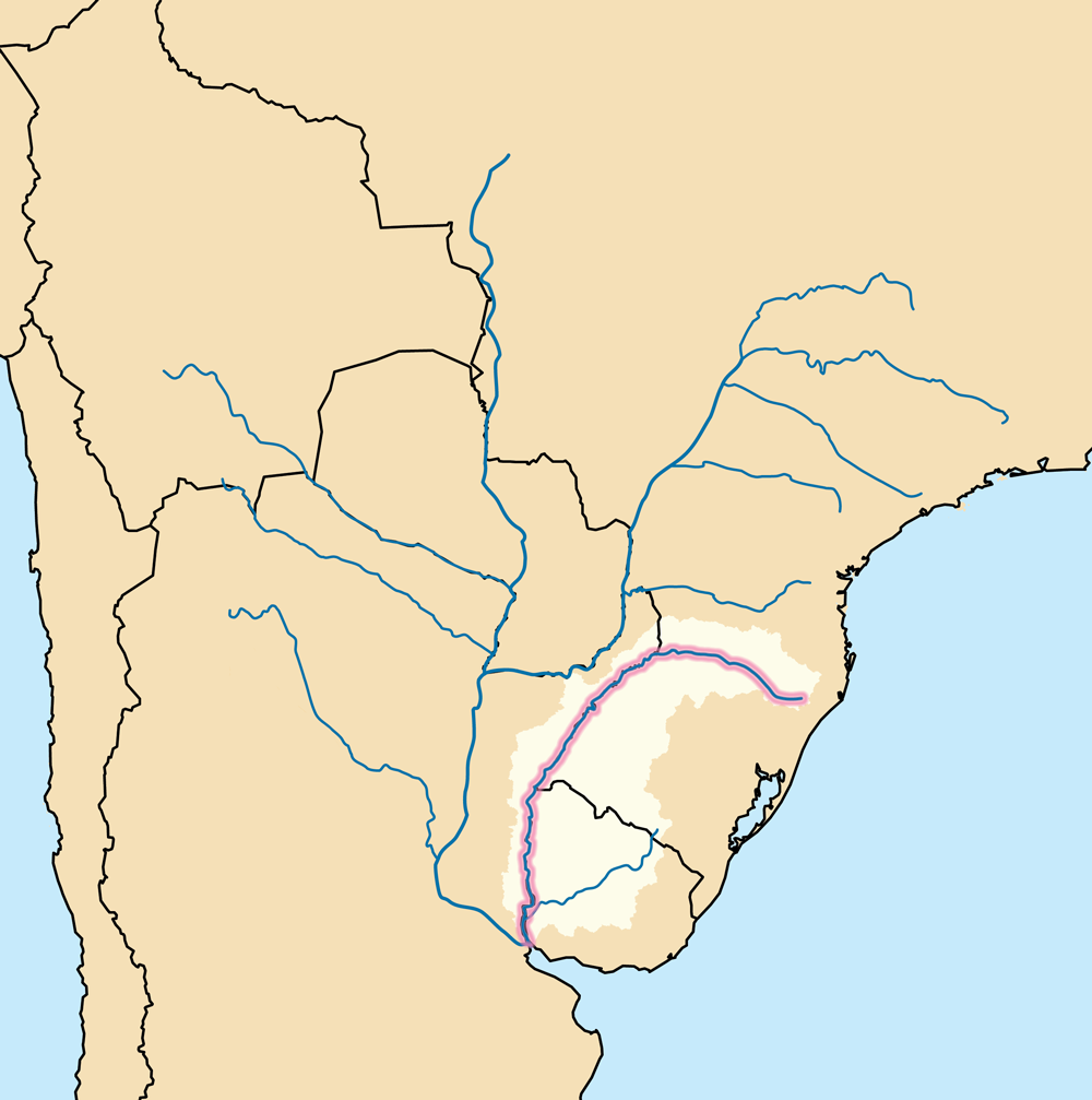
| વર્ણન |
A map showing the Uruguay Basin (pale tan) — the drainage basin of the Uruguay River (highlighted).
|
| તારીખ | |
| સ્રોત | Own work using Digital Chart of the World and GTOPO data. |
| લેખક | Kmusser |
હું, આ કાર્યનો પ્રકાશનાધિકાર ધારક, તેને નીચેના પરવાના હેઠળ અહીં પ્રકાશીત કરૂં છું:
આ ફાઈલ વપરાશની પરવાનગી : Creative Commons Attribution-Share Alike 3.0 Unported license.
- તમે મુક્ત છો:
- વહેંચવા – નકલ કરવા, વિતરણ કરવા અને રચનાઓ મોકલવા
- રીમિક્સ કરવા કે મઠારવા – રચના અપનાવવા
- નીચેની શરત હેઠળ:
- આરોપણ – તમારે આ રચનાનો ઉપયોગ કરવા માટે લેખક કે પ્રકાશન અધિકાર ધારકની યોગ્ય માહિતી, પરવાનગી (લાયસન્સ)ની કડી અને તેમાં ફેરફાર કર્યો હોય તો તેનો ઉલ્લેખ કરવો જ પડશે. તમે આ સત્તા અનુસાર જ આ રચનાનો પ્રયોગ થવો જોઈએ, પણ તેઓ તમને અથવા તમારા ઉપયોગ સાથે સંમત થાય છે તે રીતે નહીં.
- શેર- અલાઈક (બિન ભેદભાવ વહેંચણી) – તમે જો આ રચનાને બદલશો, તેમાં ફેરફાર કરશો અથવા તેના પર આધારિત કોઇ કાર્ય બનાવશો તો તમારે પરિણામી કાર્યને તે જ અથવા અનુરૂપ પરવાનગી હેઠળ જ પ્રકાશિત કરવું પડશે.
ફાઇલનો ઇતિહાસ
તારીખ/સમય ઉપર ક્લિક કરવાથી તે સમયે ફાઇલ કેવી હતી તે જોવા મળશે.
| તારીખ/સમય | લઘુચિત્ર | પરિમાણો | સભ્ય | ટિપ્પણી | |
|---|---|---|---|---|---|
| વર્તમાન | ૦૦:૦૯, ૨૦ જુલાઇ ૨૦૧૦ | | ૧,૦૦૦ × ૧,૦૦૭ (૨૧૭ KB) | Kmusser | added highlighting, deleted border |
| ૦૦:૩૨, ૧૮ ડિસેમ્બર ૨૦૦૯ |  | ૧,૦૦૦ × ૧,૦૦૦ (૨૩૫ KB) | Kmusser | {{Information |Description=This is a map showing the Uruguay River and its drainage basin including its longest tributary, the Río Negro. |Source=Own work using [http://www.maproom.psu.edu/dcw/ Digital Cha |
ફાઇલનો વપરાશ
આ ફાઇલને કોઇ પાનાં વાપરતા નથી.
ફાઇલનો વ્યાપક ઉપયોગ
નીચેની બીજી વિકિઓ આ ફાઈલ વાપરે છે:
- af.wikipedia.org પર વપરાશ
- an.wikipedia.org પર વપરાશ
- arz.wikipedia.org પર વપરાશ
- azb.wikipedia.org પર વપરાશ
- bs.wikipedia.org પર વપરાશ
- cs.wikipedia.org પર વપરાશ
- da.wikipedia.org પર વપરાશ
- en.wikipedia.org પર વપરાશ
- fi.wikipedia.org પર વપરાશ
- he.wikipedia.org પર વપરાશ
- hr.wikipedia.org પર વપરાશ
- id.wikipedia.org પર વપરાશ
- ja.wikipedia.org પર વપરાશ
- lv.wikipedia.org પર વપરાશ
- mk.wikipedia.org પર વપરાશ
- mr.wikipedia.org પર વપરાશ
- nl.wikipedia.org પર વપરાશ
- no.wikipedia.org પર વપરાશ
- pl.wiktionary.org પર વપરાશ
- ru.wikipedia.org પર વપરાશ
- sk.wikipedia.org પર વપરાશ
- sl.wikipedia.org પર વપરાશ
- sv.wikipedia.org પર વપરાશ
- ta.wikipedia.org પર વપરાશ
- th.wikipedia.org પર વપરાશ
- tr.wikipedia.org પર વપરાશ
- www.wikidata.org પર વપરાશ