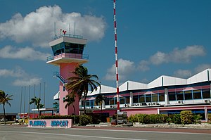
Flamingo International Airport
airport on Bonaire Island in the Netherlands Antilles
દેશ
પ્રશાસન વિભાગમાં આવેલ છે
Kralendijk
સ્થળના અક્ષાંસ રેખાંશ
સમુદ્ર સપાટીથી ઉંચાઇ
૨૪ foot
સત્તાવાર ઉદ્ઘાટનની તારીખ
1945
patronage
અધિકૃત વેબસાઇટ
on focus list of Wikimedia project
Wiki goes Caribbean
state of use
in use
runway
10/28
વપરાયેલ પદાર્થો: bitumen
લંબાઈ: ૨,૮૮૦ મીટર
IATA airport code
BON
ICAO airport code
TNCB
કોમન્સ શ્રેણી
Bonaire International Airport
સંદર્ભ
- ↑ GeoNames
- ↑ Freebase Data Dumps, ૨૮ ઓક્ટોબર 2013
- ↑ ૩.૦ ૩.૧ https://store.aci.aero/wp-content/uploads/2018/05/2014_Traffic_Report_sample.xlsx
- ↑ https://www.cbs.nl/en-gb/news/2018/13/5-percent-more-air-traffic-in-the-caribbean-netherlands#id=undefined

