
ચિત્ર:Detailed SVG map of the Anglophone world.svg

Size of this PNG preview of this SVG file: ૮૦૦ × ૪૧૧ પિક્સેલ. અન્ય આવર્તનો: ૩૨૦ × ૧૬૪ પિક્સેલ | ૬૪૦ × ૩૨૯ પિક્સેલ | ૧,૦૨૪ × ૫૨૬ પિક્સેલ | ૧,૨૮૦ × ૬૫૭ પિક્સેલ | ૨,૫૬૦ × ૧,૩૧૪ પિક્સેલ.
મૂળભુત ફાઇલ (SVG ફાઇલ, માત્ર ૨,૫૬૦ × ૧,૩૧૪ પીક્સલ, ફાઇલનું કદ: ૧.૩૮ MB)
સારાંશ:
| વર્ણન |
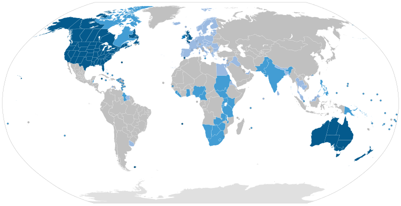
English: Majority native language
Co-official and majority native language
Official but minority native language
Secondary language: spoken as a second language by more than 20% of the population, de facto working language of government, language of instruction in education, etc. |
| તારીખ | |
| સ્રોત | Speaker figures based on Ethnologue and other sources. Blank map: File:BlankMap-World6-Subdivisions.svg |
| લેખક | Jpthefish |
પરવાના
હું, આ કાર્યનો પ્રકાશનાધિકાર ધારક, તેને નીચેના પરવાના હેઠળ અહીં પ્રકાશીત કરૂં છું:
This file is licensed under the Creative Commons Attribution-Share Alike 4.0 International license.
- તમે મુક્ત છો:
- વહેંચવા – નકલ કરવા, વિતરણ કરવા અને રચનાઓ મોકલવા
- રીમિક્સ કરવા કે મઠારવા – રચના અપનાવવા
- નીચેની શરત હેઠળ:
- આરોપણ – તમારે આ રચનાનો ઉપયોગ કરવા માટે લેખક કે પ્રકાશન અધિકાર ધારકની યોગ્ય માહિતી, પરવાનગી (લાયસન્સ)ની કડી અને તેમાં ફેરફાર કર્યો હોય તો તેનો ઉલ્લેખ કરવો જ પડશે. તમે આ સત્તા અનુસાર જ આ રચનાનો પ્રયોગ થવો જોઈએ, પણ તેઓ તમને અથવા તમારા ઉપયોગ સાથે સંમત થાય છે તે રીતે નહીં.
- શેર- અલાઈક (બિન ભેદભાવ વહેંચણી) – તમે જો આ રચનાને બદલશો, તેમાં ફેરફાર કરશો અથવા તેના પર આધારિત કોઇ કાર્ય બનાવશો તો તમારે પરિણામી કાર્યને તે જ અથવા અનુરૂપ પરવાનગી હેઠળ જ પ્રકાશિત કરવું પડશે.
ફાઇલનો ઇતિહાસ
તારીખ/સમય ઉપર ક્લિક કરવાથી તે સમયે ફાઇલ કેવી હતી તે જોવા મળશે.
| તારીખ/સમય | લઘુચિત્ર | પરિમાણો | સભ્ય | ટિપ્પણી | |
|---|---|---|---|---|---|
| વર્તમાન | ૧૫:૨૧, ૨૬ ઓગસ્ટ ૨૦૨૩ | | ૨,૫૬૦ × ૧,૩૧૪ (૧.૩૮ MB) | Kwamikagami | rv: you just removed light blue, which we use on other maps |
| ૦૭:૦૫, ૨૬ ઓગસ્ટ ૨૦૨૩ |  | ૨,૫૬૦ × ૧,૩૧૪ (૧.૩૬ MB) | Jpthefish | Reverted to version as of 01:23, 3 July 2020 (UTC) Forgive me if I am mistaken, but I have not seen sources to corroborate the light blue coloring of the EU, SE Asia, or other regions. The light blue color in my other maps was previously reserved for lanauges with cultural or secondary status - that is, a historically significant language and/or a language spoken by over 20% of the native population. I am open to changes though, as long as they are consistent across all SVG maps and reflect a... | |
| ૧૧:૧૨, ૯ ઓગસ્ટ ૨૦૨૩ |  | ૨,૫૬૦ × ૧,૩૧૪ (૧.૩૮ MB) | Kwamikagami | some countries marked as majority English were majority creole | |
| ૧૨:૦૩, ૧૫ જાન્યુઆરી ૨૦૨૩ |  | ૨,૫૬૦ × ૧,૩૧૪ (૧.૩૮ MB) | Kwamikagami | clean up Quebec; Faroes assumed | |
| ૧૧:૨૦, ૧૫ જાન્યુઆરી ૨૦૨૩ |  | ૨,૫૬૦ × ૧,૩૧૪ (૧.૩૮ MB) | Kwamikagami | 2nd language >20%, & de facto govt working language, per Ethnologue. | |
| ૦૬:૫૩, ૩ જુલાઇ ૨૦૨૦ |  | ૨,૫૬૦ × ૧,૩૧૪ (૧.૩૬ MB) | Jpthefish | New section | |
| ૦૪:૧૭, ૯ જૂન ૨૦૨૦ |  | ૨,૫૬૦ × ૧,૩૧૪ (૧.૩૬ MB) | Jpthefish | Lighter secondary colors | |
| ૨૨:૪૭, ૨૫ મે ૨૦૨૦ |  | ૨,૫૬૦ × ૧,૩૧૪ (૧.૩૬ MB) | Jpthefish | edit Channel Islands | |
| ૨૩:૪૯, ૮ મે ૨૦૨૦ |  | ૨,૫૬૦ × ૧,૩૧૪ (૧.૩૬ MB) | Jpthefish | Add Cameroon | |
| ૦૭:૪૫, ૮ મે ૨૦૨૦ |  | ૨,૫૬૦ × ૧,૩૧૪ (૧.૩૬ MB) | Jpthefish | Uploaded own work with UploadWizard |
ફાઇલનો વપરાશ
આ ફાઇલને કોઇ પાનાં વાપરતા નથી.
ફાઇલનો વ્યાપક ઉપયોગ
નીચેની બીજી વિકિઓ આ ફાઈલ વાપરે છે:
- af.wikipedia.org પર વપરાશ
- ang.wikipedia.org પર વપરાશ
- ar.wikipedia.org પર વપરાશ
- ast.wikipedia.org પર વપરાશ
- av.wikipedia.org પર વપરાશ
- az.wikipedia.org પર વપરાશ
- ba.wikipedia.org પર વપરાશ
- be.wikipedia.org પર વપરાશ
- bg.wikipedia.org પર વપરાશ
- bn.wikipedia.org પર વપરાશ
- br.wikipedia.org પર વપરાશ
- cv.wikipedia.org પર વપરાશ
- en.wikipedia.org પર વપરાશ
- en.wikibooks.org પર વપરાશ
- es.wikipedia.org પર વપરાશ
- fa.wikipedia.org પર વપરાશ
- fr.wikipedia.org પર વપરાશ
- ga.wikipedia.org પર વપરાશ
- guc.wikipedia.org પર વપરાશ
- he.wikipedia.org પર વપરાશ
- hr.wikipedia.org પર વપરાશ
- hy.wikipedia.org પર વપરાશ
- id.wikipedia.org પર વપરાશ
- incubator.wikimedia.org પર વપરાશ
- it.wikipedia.org પર વપરાશ
આ ફાઇલના વધુ વૈશ્વિક વપરાશ જુઓ.