
ચિત્ર:East Above Corniglia Cinque Terre crop Sep23 A7C 06797.jpg

આ પૂર્વાવલોકનનું કદ: ૭૯૯ × ૫૯૯ પિક્સેલ. અન્ય આવર્તનો: ૩૨૦ × ૨૪૦ પિક્સેલ | ૬૪૦ × ૪૮૦ પિક્સેલ | ૧,૦૨૪ × ૭૬૮ પિક્સેલ | ૧,૨૮૦ × ૯૬૦ પિક્સેલ | ૨,૫૬૦ × ૧,૯૨૦ પિક્સેલ | ૪,૬૨૬ × ૩,૪૭૦ પિક્સેલ.
મૂળભુત ફાઇલ (૪,૬૨૬ × ૩,૪૭૦ પીક્સલ, ફાઇલનું કદ: ૧૯.૧૭ MB, MIME પ્રકાર: image/jpeg)
સારાંશ:
| વર્ણન |
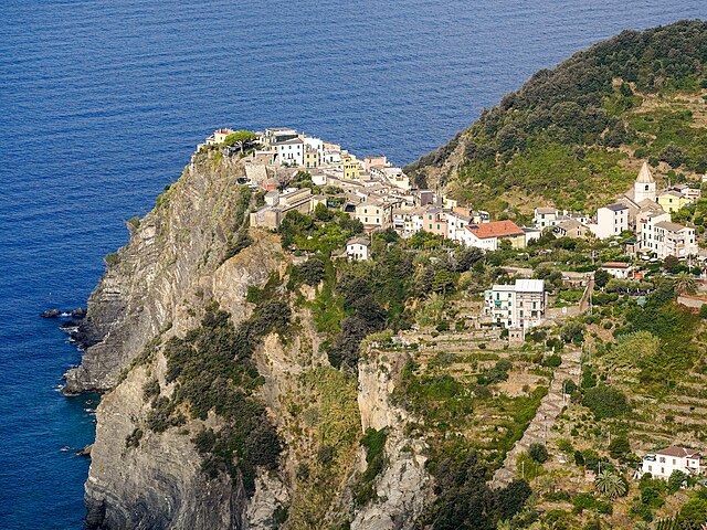
English: Corniglia perched on a 300 ft (91 m) cliff. View from the east, on Trail 587 Corniglia towards Volastra, about 260 m (850 ft) above the village. San Pietro Church middle right. Zigzag staircase down to the railway station lower right. Cinque Terre, Liguria, Italy |
|||
| તારીખ | ||||
| સ્રોત | પોતાની રચના | |||
| લેખક |
|
|||
| અન્ય આવૃત્તિઓ |
|


| Camera location | | View this and other nearby images on: OpenStreetMap |
|---|
The geographical information in this file was retrospectively estimated.
The location may therefore be somewhat imprecise. Verifying and refining these coordinates is strongly encouraged. |
|
This place is a UNESCO World Heritage Site, listed as
Portovenere, Cinque Terre, and the Islands (Italy).
|
Assessment
|
પરવાના
હું, આ કાર્યનો પ્રકાશનાધિકાર ધારક, તેને નીચેના પરવાના હેઠળ અહીં પ્રકાશીત કરૂં છું:
This file is licensed under the Creative Commons Attribution-Share Alike 4.0 International license.
- તમે મુક્ત છો:
- વહેંચવા – નકલ કરવા, વિતરણ કરવા અને રચનાઓ મોકલવા
- રીમિક્સ કરવા કે મઠારવા – રચના અપનાવવા
- નીચેની શરત હેઠળ:
- આરોપણ – તમારે આ રચનાનો ઉપયોગ કરવા માટે લેખક કે પ્રકાશન અધિકાર ધારકની યોગ્ય માહિતી, પરવાનગી (લાયસન્સ)ની કડી અને તેમાં ફેરફાર કર્યો હોય તો તેનો ઉલ્લેખ કરવો જ પડશે. તમે આ સત્તા અનુસાર જ આ રચનાનો પ્રયોગ થવો જોઈએ, પણ તેઓ તમને અથવા તમારા ઉપયોગ સાથે સંમત થાય છે તે રીતે નહીં.
- શેર- અલાઈક (બિન ભેદભાવ વહેંચણી) – તમે જો આ રચનાને બદલશો, તેમાં ફેરફાર કરશો અથવા તેના પર આધારિત કોઇ કાર્ય બનાવશો તો તમારે પરિણામી કાર્યને તે જ અથવા અનુરૂપ પરવાનગી હેઠળ જ પ્રકાશિત કરવું પડશે.
ફાઇલનો ઇતિહાસ
તારીખ/સમય ઉપર ક્લિક કરવાથી તે સમયે ફાઇલ કેવી હતી તે જોવા મળશે.
| તારીખ/સમય | લઘુચિત્ર | પરિમાણો | સભ્ય | ટિપ્પણી | |
|---|---|---|---|---|---|
| વર્તમાન | ૦૯:૫૬, ૨૨ એપ્રિલ ૨૦૨૪ | | ૪,૬૨૬ × ૩,૪૭૦ (૧૯.૧૭ MB) | Tagooty | Uploaded own work with UploadWizard |
ફાઇલનો વપરાશ
આ ફાઇલને કોઇ પાનાં વાપરતા નથી.
ફાઇલનો વ્યાપક ઉપયોગ
નીચેની બીજી વિકિઓ આ ફાઈલ વાપરે છે:
- en.wikipedia.org પર વપરાશ
- frp.wikipedia.org પર વપરાશ
- fr.wikipedia.org પર વપરાશ
- Discussion utilisateur:Blue02
- Wikipédia:Détente
- Discussion utilisateur:La Cigale/Bac à gravier
- Discussion utilisateur:Cattzy
- Discussion utilisateur:H du Viala
- Discussion utilisateur:Paulokoko
- Discussion utilisateur:Yodie/Septembre 2007 - Septembre 2009
- Discussion utilisateur:Infofiltrage
- Discussion utilisatrice:Tella/Archive 6
- Discussion utilisateur:WikiDreamer
- Discussion utilisateur:Futon
- Discussion utilisateur:Rvince
- Discussion utilisateur:Nanoxyde/Archives 04
- Utilisateur:Mikani/Archive/wikimag
- Discussion utilisateur:Xfigpower/Archive2008 S2
- Discussion utilisateur:Delhovlyn/Archive (2)
- Discussion utilisateur:Otourly/Archive 2
- Discussion utilisateur:Riba/Archive 2
- Discussion utilisateur:Aeleftherios/Archives 2008
- Discussion utilisateur:Thesupermat/Archive2
- Discussion utilisateur:Croquant/Archive2
- Discussion utilisateur:Zouavman Le Zouave/Archive (4)
- Discussion utilisateur:Salix/Archives 2e semestre 2008
- Discussion utilisateur:Elfix/Archives/01 Avril-fin octobre 2008
- Discussion utilisateur:Mikani/2008
- Utilisateur:Naloufan/Divertissement
- Wikipédia:Image du jour/19 mai 2024
- Wikipédia:Image du jour/mai 2024
- Wikipédia:Wikimag/2024/20
- Wikipédia:Réseaux sociaux/X/Publications/archives/mai 2024