ચિત્ર:Geographic distribution of Bengali language.png

Page contents not supported in other languages.
વિકિપીડિયામાંથી

મૂળભુત ફાઇલ(૨,૮૦૬ × ૨,૦૮૦ પીક્સલ, ફાઇલનું કદ: ૧.૩૬ MB, MIME પ્રકાર: image/png)

આ ફાઇલ Wikimedia Commonsનો ભાગ છે અને શક્ય છે કે અન્ય પ્રકલ્પોમાં પણ વપરાઇ હોય. ત્યાંનાં મૂળ ફાઇલનાં વર્ણનનાં પાના પર આપેલું વર્ણન નીચે દર્શાવેલું છે.

સારાંશ:

વર્ણન
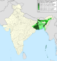
Ελληνικά: Γεωγραφική κατανομή της Βεγγαλικής Γλώσσας ανά επαρχία της Ινδίας και στο Μπανγκλαντές, τα χρώματα στις επαρχίες ποικίλουν ανάλογα με το ποσοστό ομιλητών (δεδομένα απογραφής 2011). Παράγωγο του αρχείου India district map (de-facto).svg.
English: Geographic distribution of Bengali language in India and Bangladesh. The map covers each district of India and the five shades of green show the percentage of Bengali language speakers in each district. Source: Indian census 2011. Feel free to enrich the map with data for more Indian districts, or fix any mistakes. Derivative of the file India district map (de-facto).svg.
તારીખ
સ્રોત પોતાની રચના
લેખક NikosLikomitros

પરવાના

હું, આ કાર્યનો પ્રકાશનાધિકાર ધારક, તેને નીચેના પરવાના હેઠળ અહીં પ્રકાશીત કરૂં છું:
w:en:Creative Commons
આરોપણ શેર- અલાઈક (બિન ભેદભાવ વહેંચણી)
This file is licensed under the Creative Commons Attribution-Share Alike 4.0 International license.
તમે મુક્ત છો:
  • વહેંચવા – નકલ કરવા, વિતરણ કરવા અને રચનાઓ મોકલવા
  • રીમિક્સ કરવા કે મઠારવા – રચના અપનાવવા
નીચેની શરત હેઠળ:
  • આરોપણ – તમારે આ રચનાનો ઉપયોગ કરવા માટે લેખક કે પ્રકાશન અધિકાર ધારકની યોગ્ય માહિતી, પરવાનગી ‍(‌લાયસન્સ)ની કડી અને તેમાં ફેરફાર કર્યો હોય તો તેનો ઉલ્લેખ કરવો જ પડશે. તમે આ સત્તા અનુસાર જ આ રચનાનો પ્રયોગ થવો જોઈએ, પણ તેઓ તમને અથવા તમારા ઉપયોગ સાથે સંમત થાય છે તે રીતે નહીં.
  • શેર- અલાઈક (બિન ભેદભાવ વહેંચણી) – તમે જો આ રચનાને બદલશો, તેમાં ફેરફાર કરશો અથવા તેના પર આધારિત કોઇ કાર્ય બનાવશો તો તમારે પરિણામી કાર્યને તે જ અથવા અનુરૂપ પરવાનગી હેઠળ જ પ્રકાશિત કરવું પડશે.

Captions

Add a one-line explanation of what this file represents
Geographic distribution of Bengali language in India and Bangladesh. The map covers each district of India and the five shades of green show the percentage of Bengali language speakers in each district. Source: Indian census 2011.

Items portrayed in this file

દર્શાવે છે

media type અંગ્રેજી

image/png

source of file અંગ્રેજી

original creation by uploader અંગ્રેજી

ફાઇલનો ઇતિહાસ

તારીખ/સમય ઉપર ક્લિક કરવાથી તે સમયે ફાઇલ કેવી હતી તે જોવા મળશે.

તારીખ/સમયલઘુચિત્રપરિમાણોસભ્યટિપ્પણી
વર્તમાન૨૦:૩૫, ૨ જુલાઇ ૨૦૨૨૨૦:૩૫, ૨ જુલાઇ ૨૦૨૨નું લઘુચિત્ર સંસ્કરણ૨,૮૦૬ × ૨,૦૮૦ (૧.૩૬ MB)NikosLikomitrosA few districts of Arunachal Pradesh have a notable Bengali presence above of 1%, probably part of the Indian efforts to increase its presence in the region.
૨૨:૨૫, ૧ જુલાઇ ૨૦૨૨૨૨:૨૫, ૧ જુલાઇ ૨૦૨૨નું લઘુચિત્ર સંસ્કરણ૨,૮૦૬ × ૨,૦૮૦ (૧.૩૬ MB)NikosLikomitrosTwo extra fixes.
૨૨:૨૩, ૧ જુલાઇ ૨૦૨૨૨૨:૨૩, ૧ જુલાઇ ૨૦૨૨નું લઘુચિત્ર સંસ્કરણ૨,૮૦૬ × ૨,૦૮૦ (૧.૩૬ MB)NikosLikomitrosMinor fixes.
૨૨:૧૪, ૧ જુલાઇ ૨૦૨૨૨૨:૧૪, ૧ જુલાઇ ૨૦૨૨નું લઘુચિત્ર સંસ્કરણ૨,૮૦૬ × ૨,૦૮૦ (૧.૩૬ MB)NikosLikomitrosNow, this map covers all districts of India. Includes also extra information and a new colour key. The basemap is from Distribution_of_Jats_in_South_Asia.png.
૦૨:૩૯, ૨૭ જૂન ૨૦૨૨૦૨:૩૯, ૨૭ જૂન ૨૦૨૨નું લઘુચિત્ર સંસ્કરણ૧,૯૦૨ × ૨,૦૪૮ (૧,૦૦૨ KB)NikosLikomitrosUploaded own work with UploadWizard

આ ફાઇલને કોઇ પાનાં વાપરતા નથી.

ફાઇલનો વ્યાપક ઉપયોગ

નીચેની બીજી વિકિઓ આ ફાઈલ વાપરે છે:

મૅટાડેટા