
ચિત્ર:Airports and seaports map.png
આ પૂર્વાવલોકનનું કદ: ૫૨૭ × ૬૦૦ પિક્સેલ. અન્ય આવર્તનો: ૨૧૧ × ૨૪૦ પિક્સેલ | ૪૨૨ × ૪૮૦ પિક્સેલ | ૧,૦૦૦ × ૧,૧૩૮ પિક્સેલ.
મૂળભુત ફાઇલ (૧,૦૦૦ × ૧,૧૩૮ પીક્સલ, ફાઇલનું કદ: ૨૩૬ KB, MIME પ્રકાર: image/png)
સારાંશ:

|
This economic map image could be re-created using vector graphics as an SVG file. This has several advantages; see Commons:Media for cleanup for more information. If an SVG form of this image is available, please upload it and afterwards replace this template with
{{vector version available|new image name}}.
It is recommended to name the SVG file “Airports and seaports map.svg”—then the template Vector version available (or Vva) does not need the new image name parameter. |

|
This file requires updating. Please see the talk page for more information. In doing so, you could add a timestamp to the file.
|
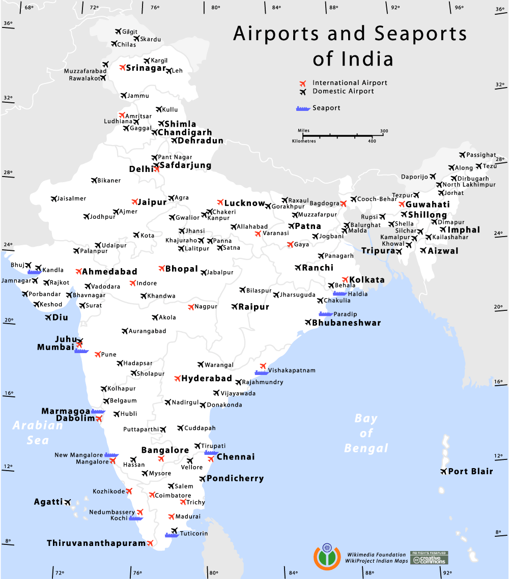
Airports and Seaports map of India
Author
હું, આ કાર્યનો પ્રકાશનાધિકાર ધારક, તેને નીચેના પરવાનાઓ હેઠળ અહીં પ્રકાશીત કરૂં છું:

|
આ રચનાની નકલ કરવા, વિતરણ અને સુધારો કરવા માટે GNU Free Documentation License, આવૃત્તિ 1.2 કે અન્ય આગળની આવૃત્તિ Free Software Foundation હેઠળ પરવાનગી છે; જેમાં કોઈ Invariant Sections, no Front-Cover Texts, and no Back-Cover Texts નથી. આ પરવાનાની પ્રત GNU Free Documentation License વિભાગમાં છે. |
| આ ફાઈલ વપરાશની પરવાનગી : Creative Commons Attribution-Share Alike 3.0 Unported license. | ||
| ||
| GFDL licensing update ના ભાગ રૂપે આ પરવાનાનો ટેગ ફાઈલ પર લગાડવામાં આવ્યો છે. |
આ ફાઈલ વપરાશની પરવાનગી : Creative Commons Attribution-Share Alike 2.5 Generic, 2.0 Generic and 1.0 Generic license.
- તમે મુક્ત છો:
- વહેંચવા – નકલ કરવા, વિતરણ કરવા અને રચનાઓ મોકલવા
- રીમિક્સ કરવા કે મઠારવા – રચના અપનાવવા
- નીચેની શરત હેઠળ:
- આરોપણ – તમારે આ રચનાનો ઉપયોગ કરવા માટે લેખક કે પ્રકાશન અધિકાર ધારકની યોગ્ય માહિતી, પરવાનગી (લાયસન્સ)ની કડી અને તેમાં ફેરફાર કર્યો હોય તો તેનો ઉલ્લેખ કરવો જ પડશે. તમે આ સત્તા અનુસાર જ આ રચનાનો પ્રયોગ થવો જોઈએ, પણ તેઓ તમને અથવા તમારા ઉપયોગ સાથે સંમત થાય છે તે રીતે નહીં.
- શેર- અલાઈક (બિન ભેદભાવ વહેંચણી) – તમે જો આ રચનાને બદલશો, તેમાં ફેરફાર કરશો અથવા તેના પર આધારિત કોઇ કાર્ય બનાવશો તો તમારે પરિણામી કાર્યને તે જ અથવા અનુરૂપ પરવાનગી હેઠળ જ પ્રકાશિત કરવું પડશે.
તમે તમારી પસંદગીનો પરવાનો પસંદ કરી શકો છો.
de:Bild:Airports and seaports map.png
Am confused wid the number of international airports. its 13 here. i had read der r only 11.. which is the correct data?
| Annotations | This image is annotated: View the annotations at Commons |
ફાઇલનો ઇતિહાસ
તારીખ/સમય ઉપર ક્લિક કરવાથી તે સમયે ફાઇલ કેવી હતી તે જોવા મળશે.
| તારીખ/સમય | લઘુચિત્ર | પરિમાણો | સભ્ય | ટિપ્પણી | |
|---|---|---|---|---|---|
| વર્તમાન | ૦૨:૨૭, ૧૨ જાન્યુઆરી ૨૦૧૪ | | ૧,૦૦૦ × ૧,૧૩૮ (૨૩૬ KB) | RaviC | +Kargil |
| ૦૨:૧૧, ૨૯ ઓક્ટોબર ૨૦૧૨ |  | ૧,૦૦૦ × ૧,૧૩૮ (૨૬૩ KB) | RaviC | Added all Intl airports not currently listed correctly. | |
| ૨૩:૫૬, ૨૮ ઓક્ટોબર ૨૦૧૨ |  | ૧,૦૦૦ × ૧,૧૩૮ (૧૬૧ KB) | RaviC | Removed vandalism | |
| ૧૦:૩૯, ૨૫ સપ્ટેમ્બર ૨૦૧૨ |  | ૧,૦૦૦ × ૧,૧૩૮ (૨૫૬ KB) | Wantsallanger | updated international status for srinagar etc as per source http://164.100.47.132/LssNew/psearch/QResult15.aspx?qref=78747 | |
| ૦૦:૦૪, ૮ મે ૨૦૧૦ |  | ૧,૦૦૦ × ૧,૧૩૮ (૧૮૦ KB) | RaviC | finished adding airports in | |
| ૨૨:૫૯, ૭ મે ૨૦૧૦ |  | ૧,૦૦૦ × ૧,૧૩૮ (૧૭૯ KB) | RaviC | Added more airports in the Kashmir region | |
| ૦૧:૦૩, ૭ મે ૨૦૧૦ |  | ૧,૦૦૦ × ૧,૧૩૮ (૧૭૮ KB) | RaviC | Added airports in other areas of Kashmir. However, I cannot add all the names since I don't have the font. | |
| ૨૦:૩૫, ૧૧ જાન્યુઆરી ૨૦૦૬ |  | ૧,૦૦૦ × ૧,૧૩૮ (૧૦૮ KB) | Planemad | Airports and Seaports map of India ==Author== w:user:planemad ==Revision== Original Category:Maps of India Category:Wikiproject Indian Maps |
ફાઇલનો વપરાશ
આ ફાઇલ માં નીચેનું પાનું વપરાયેલું છે:
ફાઇલનો વ્યાપક ઉપયોગ
નીચેની બીજી વિકિઓ આ ફાઈલ વાપરે છે:
- bh.wikipedia.org પર વપરાશ
- bn.wikipedia.org પર વપરાશ
- ce.wikipedia.org પર વપરાશ
- de.wikipedia.org પર વપરાશ
- en.wikipedia.org પર વપરાશ
- en.wikivoyage.org પર વપરાશ
- fa.wikipedia.org પર વપરાશ
- fa.wikivoyage.org પર વપરાશ
- fr.wikipedia.org પર વપરાશ
- hi.wikipedia.org પર વપરાશ
- hi.wikibooks.org પર વપરાશ
- it.wikivoyage.org પર વપરાશ
- ja.wikipedia.org પર વપરાશ
- kn.wikipedia.org પર વપરાશ
- ml.wikipedia.org પર વપરાશ
- mr.wikipedia.org પર વપરાશ
- new.wikipedia.org પર વપરાશ
- nl.wikipedia.org પર વપરાશ
- pa.wikipedia.org પર વપરાશ
- pl.wikipedia.org પર વપરાશ
- ru.wikipedia.org પર વપરાશ
- sq.wikipedia.org પર વપરાશ
- ta.wikipedia.org પર વપરાશ
- te.wikipedia.org પર વપરાશ
- zh.wikipedia.org પર વપરાશ