
ચિત્ર:Niger saharan medieval trade routes.PNG
આ પૂર્વાવલોકનનું કદ: ૮૦૦ × ૩૧૯ પિક્સેલ. અન્ય આવર્તનો: ૩૨૦ × ૧૨૮ પિક્સેલ | ૮૧૭ × ૩૨૬ પિક્સેલ.
મૂળભુત ફાઇલ (૮૧૭ × ૩૨૬ પીક્સલ, ફાઇલનું કદ: ૨૬૩ KB, MIME પ્રકાર: image/png)
સારાંશ:
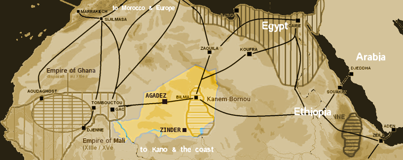
| વર્ણન |
English: Map showing the main trans-Saharan caravan routes circa 1400. Also shown are the Ghana Empire (until the 13th century) and 13th – 15th century Mali Empire. Note the western route running from Djenné via Timbuktu to Sijilmassa. Present day Niger in yellow. Español: Mapa que muestra las principales rutas de caravanas transaharianas alrededor de 1400. También se muestran el Imperio de Ghana (hasta el siglo XIII) y el Imperio de Mali del siglo XIII-XV. Tenga en cuenta la ruta occidental que va desde Djenné a través de Tombuctú a Sijilmassa. En amarillo la extensión del Níger actual. |
| તારીખ | |
| સ્રોત | self-made using The Gimp and Image:Africa historical traite.JPG |
| લેખક | T L Miles |
| પરવાનગી (આ ફાઈલનો ફરી ઉપયોગ) |
Public Domain |

|
This map image could be re-created using vector graphics as an SVG file. This has several advantages; see Commons:Media for cleanup for more information. If an SVG form of this image is available, please upload it and afterwards replace this template with
{{vector version available|new image name}}.
It is recommended to name the SVG file “Niger saharan medieval trade routes.svg”—then the template Vector version available (or Vva) does not need the new image name parameter. |
પરવાના
| હું, આ રચનાઓ પ્રકાશન અધિકાર ધારક, આ રચનાને public domain પર પ્રકાશિત કરું છું. આ સમગ્ર વિશ્વમઆં કાર્યરત રહેશે. અમુક દેશોમાં કાયદેસર રીતે તે શક્ય નથી, જો તેમ હોય તો : કો કોઈને પણ કોઈપણ વપરાશ, કોઇ પણ શરત વગર, માટે આ રચના વાપરવાની છૂટ આપું છું સિવાયકે તે શરતો કાયદેસર જરૂરી હોય. |
ફાઇલનો ઇતિહાસ
તારીખ/સમય ઉપર ક્લિક કરવાથી તે સમયે ફાઇલ કેવી હતી તે જોવા મળશે.
| તારીખ/સમય | લઘુચિત્ર | પરિમાણો | સભ્ય | ટિપ્પણી | |
|---|---|---|---|---|---|
| વર્તમાન | ૦૦:૩૯, ૧૯ જાન્યુઆરી ૨૦૦૮ | ૮૧૭ × ૩૨૬ (૨૬૩ KB) | T L Miles | {{Information |Description=Map of Medieval Saharan Trade routes, centerd on Niger |Source=self-made using The Gimp and Image:Africa historical traite.JPG |Date=2008-01-18 |Author= T L Miles |Permission=Public Domain |other_versions= } |
ફાઇલનો વપરાશ
આ ફાઇલ માં નીચેનું પાનું વપરાયેલું છે:
ફાઇલનો વ્યાપક ઉપયોગ
નીચેની બીજી વિકિઓ આ ફાઈલ વાપરે છે:
- af.wikipedia.org પર વપરાશ
- ar.wikipedia.org પર વપરાશ
- arz.wikipedia.org પર વપરાશ
- ast.wikipedia.org પર વપરાશ
- azb.wikipedia.org પર વપરાશ
- az.wikipedia.org પર વપરાશ
- ba.wikipedia.org પર વપરાશ
- be.wikipedia.org પર વપરાશ
- bn.wikipedia.org પર વપરાશ
- br.wikipedia.org પર વપરાશ
- ca.wikipedia.org પર વપરાશ
- cs.wikipedia.org પર વપરાશ
- de.wikipedia.org પર વપરાશ
- el.wikipedia.org પર વપરાશ
- en.wikipedia.org પર વપરાશ
- en.wikivoyage.org પર વપરાશ
- eo.wikipedia.org પર વપરાશ
- es.wikipedia.org પર વપરાશ
- eu.wikipedia.org પર વપરાશ
- fi.wikipedia.org પર વપરાશ
- fr.wikipedia.org પર વપરાશ
- ga.wikipedia.org પર વપરાશ
- gl.wikipedia.org પર વપરાશ
- ha.wikipedia.org પર વપરાશ
- he.wikipedia.org પર વપરાશ
- hr.wikipedia.org પર વપરાશ
- hu.wikipedia.org પર વપરાશ
- hy.wikipedia.org પર વપરાશ
આ ફાઇલના વધુ વૈશ્વિક વપરાશ જુઓ.