
ચિત્ર:Punjab district map.png

આ પૂર્વાવલોકનનું કદ: ૫૪૦ × ૬૦૦ પિક્સેલ. અન્ય આવર્તનો: ૨૧૬ × ૨૪૦ પિક્સેલ | ૪૩૨ × ૪૮૦ પિક્સેલ | ૬૯૧ × ૭૬૮ પિક્સેલ | ૯૨૨ × ૧,૦૨૪ પિક્સેલ | ૨,૪૬૭ × ૨,૭૪૧ પિક્સેલ.
મૂળભુત ફાઇલ (૨,૪૬૭ × ૨,૭૪૧ પીક્સલ, ફાઇલનું કદ: ૬૩૫ KB, MIME પ્રકાર: image/png)

|
This locator map image could be re-created using vector graphics as an SVG file. This has several advantages; see Commons:Media for cleanup for more information. If an SVG form of this image is available, please upload it and afterwards replace this template with
{{vector version available|new image name}}.
It is recommended to name the SVG file “Punjab district map.svg”—then the template Vector version available (or Vva) does not need the new image name parameter. |
સારાંશ:
| વર્ણન |
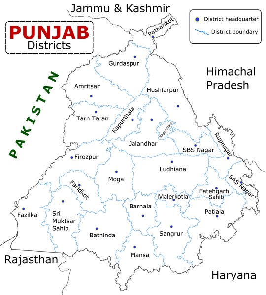
English: State of Punjab (Indian Punjab) with districts marked along with district Headquarters. |
| તારીખ | |
| સ્રોત | Self made using Inkscape. Source map referred from Punjab govt. site. |
| લેખક | Wikigringo |
પરવાના
હું, આ કાર્યનો પ્રકાશનાધિકાર ધારક, તેને નીચેના પરવાનાઓ હેઠળ અહીં પ્રકાશીત કરૂં છું:

|
આ રચનાની નકલ કરવા, વિતરણ અને સુધારો કરવા માટે GNU Free Documentation License, આવૃત્તિ 1.2 કે અન્ય આગળની આવૃત્તિ Free Software Foundation હેઠળ પરવાનગી છે; જેમાં કોઈ Invariant Sections, no Front-Cover Texts, and no Back-Cover Texts નથી. આ પરવાનાની પ્રત GNU Free Documentation License વિભાગમાં છે. |
This file is licensed under the Creative Commons Attribution-Share Alike 4.0 International, 3.0 Unported, 2.5 Generic, 2.0 Generic and 1.0 Generic license.
- તમે મુક્ત છો:
- વહેંચવા – નકલ કરવા, વિતરણ કરવા અને રચનાઓ મોકલવા
- રીમિક્સ કરવા કે મઠારવા – રચના અપનાવવા
- નીચેની શરત હેઠળ:
- આરોપણ – તમારે આ રચનાનો ઉપયોગ કરવા માટે લેખક કે પ્રકાશન અધિકાર ધારકની યોગ્ય માહિતી, પરવાનગી (લાયસન્સ)ની કડી અને તેમાં ફેરફાર કર્યો હોય તો તેનો ઉલ્લેખ કરવો જ પડશે. તમે આ સત્તા અનુસાર જ આ રચનાનો પ્રયોગ થવો જોઈએ, પણ તેઓ તમને અથવા તમારા ઉપયોગ સાથે સંમત થાય છે તે રીતે નહીં.
- શેર- અલાઈક (બિન ભેદભાવ વહેંચણી) – તમે જો આ રચનાને બદલશો, તેમાં ફેરફાર કરશો અથવા તેના પર આધારિત કોઇ કાર્ય બનાવશો તો તમારે પરિણામી કાર્યને તે જ અથવા અનુરૂપ પરવાનગી હેઠળ જ પ્રકાશિત કરવું પડશે.
તમે તમારી પસંદગીનો પરવાનો પસંદ કરી શકો છો.
ફાઇલનો ઇતિહાસ
તારીખ/સમય ઉપર ક્લિક કરવાથી તે સમયે ફાઇલ કેવી હતી તે જોવા મળશે.
| તારીખ/સમય | લઘુચિત્ર | પરિમાણો | સભ્ય | ટિપ્પણી | |
|---|---|---|---|---|---|
| વર્તમાન | ૧૪:૫૫, ૧૦ જાન્યુઆરી ૨૦૨૩ | | ૨,૪૬૭ × ૨,૭૪૧ (૬૩૫ KB) | Saad Ali Khan Pakistan | updated district MalerKotla on map |
| ૧૦:૧૫, ૭ જુલાઇ ૨૦૨૦ |  | ૨,૪૬૭ × ૨,૭૪૧ (૮૬૭ KB) | Kaushal Bishnoi | New Update version of Punjab District Map with 22 District. | |
| ૨૦:૧૧, ૫ ઓક્ટોબર ૨૦૧૩ |  | ૧,૦૯૪ × ૮૪૮ (૧૨૭ KB) | Ras67 | cropped and optimized | |
| ૧૪:૧૦, ૨૮ એપ્રિલ ૨૦૦૮ |  | ૧,૨૧૧ × ૮૭૪ (૧૮૭ KB) | Wikigringo | Uploading a better color version of the file with bigger font size. | |
| ૨૧:૩૧, ૨૬ એપ્રિલ ૨૦૦૮ |  | ૧,૨૬૯ × ૯૦૭ (૧૬૭ KB) | Wikigringo | {{Information |Description=State of Punjab, India with districts marked along with district HQ. |Source=Self made using Inkscape. Source map referred from Punjab govt. site. |Date=04/26/2008 |Author=Wikigringo |Permission= |other_versions= }} |
ફાઇલનો વપરાશ
આ ફાઇલ માં 20 નીચેનાં પાનાઓ વપરાયેલાં છે:
ફાઇલનો વ્યાપક ઉપયોગ
નીચેની બીજી વિકિઓ આ ફાઈલ વાપરે છે:
- ar.wikipedia.org પર વપરાશ
- azb.wikipedia.org પર વપરાશ
- bh.wikipedia.org પર વપરાશ
- bn.wikipedia.org પર વપરાશ
- ca.wikipedia.org પર વપરાશ
- ceb.wikipedia.org પર વપરાશ
- en.wikipedia.org પર વપરાશ
- es.wikipedia.org પર વપરાશ
- eu.wikipedia.org પર વપરાશ
- fa.wikipedia.org પર વપરાશ
- fi.wikipedia.org પર વપરાશ
- fr.wikipedia.org પર વપરાશ
- Pendjab (Inde)
- District de Barnala
- District de Faridkot
- District de Fatehgarh Sahib
- District de Fazilka
- District de Firozpur
- District de Gurdaspur
- District de Hoshiarpur
- District de Jalandhar
- District de Kapurthala
- District de Ludhiana
- District de Mansa (Penjab)
- District de Moga
- District de Mohali
- District de Muktsar
આ ફાઇલના વધુ વૈશ્વિક વપરાશ જુઓ.