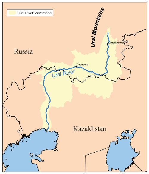
ચિત્ર:Ural river.png
Appearance
Ural_river.png (૫૦૦ × ૫૮૫ પીક્સલ, ફાઇલનું કદ: ૧૧૫ KB, MIME પ્રકાર: image/png)
ફાઇલનો ઇતિહાસ
તારીખ/સમય ઉપર ક્લિક કરવાથી તે સમયે ફાઇલ કેવી હતી તે જોવા મળશે.
| તારીખ/સમય | લઘુચિત્ર | પરિમાણો | સભ્ય | ટિપ્પણી | |
|---|---|---|---|---|---|
| વર્તમાન | ૦૩:૦૯, ૧૧ જાન્યુઆરી ૨૦૦૭ |  | ૫૦૦ × ૫૮૫ (૧૧૫ KB) | Kmusser | Lower course and basin boundary correction. |
| ૦૨:૧૭, ૨૯ નવેમ્બર ૨૦૦૫ |  | ૬૦૦ × ૬૦૦ (૨૯ KB) | Kmusser | This is a map of the Ural River Watershed. I, Karl Musser, created it based on USGS data. {{GFDL}} Category:Maps of rivers |
ફાઇલનો વપરાશ
આ ફાઇલને કોઇ પાનાં વાપરતા નથી.
ફાઇલનો વ્યાપક ઉપયોગ
નીચેની બીજી વિકિઓ આ ફાઈલ વાપરે છે:
- af.wikipedia.org પર વપરાશ
- ar.wikipedia.org પર વપરાશ
- az.wikipedia.org પર વપરાશ
- bs.wikipedia.org પર વપરાશ
- ca.wikipedia.org પર વપરાશ
- cy.wikipedia.org પર વપરાશ
- da.wikipedia.org પર વપરાશ
- de.wikipedia.org પર વપરાશ
- en.wikipedia.org પર વપરાશ
- eo.wikipedia.org પર વપરાશ
- et.wikipedia.org પર વપરાશ
- frr.wikipedia.org પર વપરાશ
- fy.wikipedia.org પર વપરાશ
- he.wikipedia.org પર વપરાશ
- id.wikipedia.org પર વપરાશ
- io.wikipedia.org પર વપરાશ
- it.wikibooks.org પર વપરાશ
- lmo.wikipedia.org પર વપરાશ
- lv.wikipedia.org પર વપરાશ
- mwl.wikipedia.org પર વપરાશ
- nl.wikipedia.org પર વપરાશ
- nn.wikipedia.org પર વપરાશ
- pl.wikipedia.org પર વપરાશ
- pms.wikipedia.org પર વપરાશ
- pt.wikipedia.org પર વપરાશ
- ro.wikipedia.org પર વપરાશ
- sh.wikipedia.org પર વપરાશ
- sk.wikipedia.org પર વપરાશ
- sq.wikipedia.org પર વપરાશ
- sv.wikipedia.org પર વપરાશ
- tr.wikipedia.org પર વપરાશ
- uk.wikipedia.org પર વપરાશ
- uz.wikipedia.org પર વપરાશ
- www.wikidata.org પર વપરાશ


