
ચિત્ર:Apprx. PRC-DPRK border around Baekdu-Changbai Mountain.PNG

આ પૂર્વાવલોકનનું કદ: ૮૦૦ × ૩૬૨ પિક્સેલ. અન્ય આવર્તનો: ૩૨૦ × ૧૪૫ પિક્સેલ | ૬૪૦ × ૨૮૯ પિક્સેલ | ૧,૦૨૪ × ૪૬૩ પિક્સેલ | ૧,૮૭૭ × ૮૪૯ પિક્સેલ.
મૂળભુત ફાઇલ (૧,૮૭૭ × ૮૪૯ પીક્સલ, ફાઇલનું કદ: ૨.૫૫ MB, MIME પ્રકાર: image/png)
સારાંશ:
| વર્ણન |
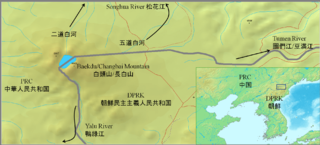
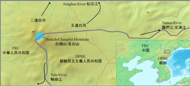
English: Approximate PRC-DPRK border around Baekdu-Changbai Mountain
日本語: 白頭山付近の中朝国境線 |
||||
| તારીખ | |||||
| સ્રોત |
|
||||
| લેખક | Jjok |
Other maps:Google map Chosun Ilbo archive copy at the Wayback Machine
પરવાના
હું, આ કાર્યનો પ્રકાશનાધિકાર ધારક, તેને નીચેના પરવાનાઓ હેઠળ અહીં પ્રકાશીત કરૂં છું:
આ ફાઈલ વપરાશની પરવાનગી : Creative Commons Attribution-Share Alike 3.0 Unported license.
- તમે મુક્ત છો:
- વહેંચવા – નકલ કરવા, વિતરણ કરવા અને રચનાઓ મોકલવા
- રીમિક્સ કરવા કે મઠારવા – રચના અપનાવવા
- નીચેની શરત હેઠળ:
- આરોપણ – તમારે આ રચનાનો ઉપયોગ કરવા માટે લેખક કે પ્રકાશન અધિકાર ધારકની યોગ્ય માહિતી, પરવાનગી (લાયસન્સ)ની કડી અને તેમાં ફેરફાર કર્યો હોય તો તેનો ઉલ્લેખ કરવો જ પડશે. તમે આ સત્તા અનુસાર જ આ રચનાનો પ્રયોગ થવો જોઈએ, પણ તેઓ તમને અથવા તમારા ઉપયોગ સાથે સંમત થાય છે તે રીતે નહીં.
- શેર- અલાઈક (બિન ભેદભાવ વહેંચણી) – તમે જો આ રચનાને બદલશો, તેમાં ફેરફાર કરશો અથવા તેના પર આધારિત કોઇ કાર્ય બનાવશો તો તમારે પરિણામી કાર્યને તે જ અથવા અનુરૂપ પરવાનગી હેઠળ જ પ્રકાશિત કરવું પડશે.

|
આ રચનાની નકલ કરવા, વિતરણ અને સુધારો કરવા માટે GNU Free Documentation License, આવૃત્તિ 1.2 કે અન્ય આગળની આવૃત્તિ Free Software Foundation હેઠળ પરવાનગી છે; જેમાં કોઈ Invariant Sections, no Front-Cover Texts, and no Back-Cover Texts નથી. આ પરવાનાની પ્રત GNU Free Documentation License વિભાગમાં છે. |
તમે તમારી પસંદગીનો પરવાનો પસંદ કરી શકો છો.
ફાઇલનો ઇતિહાસ
તારીખ/સમય ઉપર ક્લિક કરવાથી તે સમયે ફાઇલ કેવી હતી તે જોવા મળશે.
| તારીખ/સમય | લઘુચિત્ર | પરિમાણો | સભ્ય | ટિપ્પણી | |
|---|---|---|---|---|---|
| વર્તમાન | ૧૮:૫૧, ૭ ડિસેમ્બર ૨૦૧૦ | | ૧,૮૭૭ × ૮૪૯ (૨.૫૫ MB) | Suzukitaro | add lines between the large scale map and the small scale map |
| ૦૯:૦૭, ૭ સપ્ટેમ્બર ૨૦૧૦ |  | ૧,૮૭૭ × ૮૪૯ (૨.૪૪ MB) | Jjok | expanded the inset | |
| ૦૮:૪૭, ૭ સપ્ટેમ્બર ૨૦૧૦ |  | ૧,૮૮૦ × ૮૪૮ (૨.૪૫ MB) | Jjok | added names and an inset | |
| ૦૮:૪૪, ૭ સપ્ટેમ્બર ૨૦૧૦ |  | ૧,૪૬૯ × ૬૫૭ (૭૬૮ KB) | Jjok | {{Information |Description={{en|1=Approximate PRC-DPRK border around Baekdu-Changbai Mountain}} {{ja|1=白頭山付近の中朝国境線}} |Source={{Demis}} |Author=Jjok |Date=2010-09-06 |Permission= |other_versions= }} [http://maps.google.c |
ફાઇલનો વપરાશ
આ ફાઇલને કોઇ પાનાં વાપરતા નથી.
ફાઇલનો વ્યાપક ઉપયોગ
નીચેની બીજી વિકિઓ આ ફાઈલ વાપરે છે:
- arz.wikipedia.org પર વપરાશ
- bn.wikipedia.org પર વપરાશ
- en.wikipedia.org પર વપરાશ
- hi.wikipedia.org પર વપરાશ
- hu.wikipedia.org પર વપરાશ
- ja.wikipedia.org પર વપરાશ
- ko.wikipedia.org પર વપરાશ
- pa.wikipedia.org પર વપરાશ
- pnb.wikipedia.org પર વપરાશ
- pt.wikipedia.org પર વપરાશ
- www.wikidata.org પર વપરાશ
- zh.wikipedia.org પર વપરાશ