
ચિત્ર:IslandsofBombay1893.jpg
મૂળભુત ફાઇલ (૫૨૧ × ૮૦૦ પીક્સલ, ફાઇલનું કદ: ૧૦૨ KB, MIME પ્રકાર: image/jpeg)
સારાંશ:
| વર્ણન |
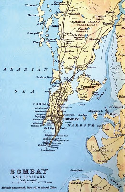
English: This is an 1893 map of the original islands of Bombay before they were merged to form the present-day geographic entity. |
||||
| તારીખ | |||||
| સ્રોત | Constable's Hand Atlas of India, 1893 edition | ||||
| લેખક | J.G. Bartholomew, Archibald Constable and Company | ||||
| પરવાનગી (આ ફાઈલનો ફરી ઉપયોગ) |
|
||||
પરવાના
This media file is in the public domain in the United States. This applies to U.S. works where the copyright has expired, often because its first publication occurred prior to January 1, 1929, and if not then due to lack of notice or renewal. See this page for further explanation.
|
 | |
 |
This image might not be in the public domain outside of the United States; this especially applies in the countries and areas that do not apply the rule of the shorter term for US works, such as Canada, Mainland China (not Hong Kong or Macao), Germany, Mexico, and Switzerland. The creator and year of publication are essential information and must be provided. See Wikipedia:Public domain and Wikipedia:Copyrights for more details.
|
ફાઇલનો ઇતિહાસ
તારીખ/સમય ઉપર ક્લિક કરવાથી તે સમયે ફાઇલ કેવી હતી તે જોવા મળશે.
| તારીખ/સમય | લઘુચિત્ર | પરિમાણો | સભ્ય | ટિપ્પણી | |
|---|---|---|---|---|---|
| વર્તમાન | ૦૮:૧૬, ૧૯ જૂન ૨૦૦૯ | | ૫૨૧ × ૮૦૦ (૧૦૨ KB) | Hunnjazal | {{Information |Description={{en|1=This is an 1893 map of the original islands of Bombay before they were merged to form the present-day geographic entity.}} |Source=Constable's Hand Atlas of India, 1893 edition |Author=J.G. Bartholomew, Archibald Constabl |
ફાઇલનો વપરાશ
આ ફાઇલ માં નીચેનું પાનું વપરાયેલું છે:
ફાઇલનો વ્યાપક ઉપયોગ
નીચેની બીજી વિકિઓ આ ફાઈલ વાપરે છે:
- ar.wikipedia.org પર વપરાશ
- az.wikipedia.org પર વપરાશ
- en.wikipedia.org પર વપરાશ
- es.wikipedia.org પર વપરાશ
- fi.wikipedia.org પર વપરાશ
- fr.wikipedia.org પર વપરાશ
- gl.wikipedia.org પર વપરાશ
- hi.wikipedia.org પર વપરાશ
- kn.wikipedia.org પર વપરાશ
- ml.wikipedia.org પર વપરાશ
- mr.wikipedia.org પર વપરાશ
- pt.wikipedia.org પર વપરાશ
- ru.wikipedia.org પર વપરાશ
- sr.wikipedia.org પર વપરાશ
- sv.wikipedia.org પર વપરાશ
- ta.wikipedia.org પર વપરાશ
- uk.wikipedia.org પર વપરાશ
- uz.wikipedia.org પર વપરાશ
- zh.wikipedia.org પર વપરાશ