
ચિત્ર:UttarakhandDistricts numbered.svg

Size of this PNG preview of this SVG file: ૬૬૬ × ૫૯૯ પિક્સેલ. અન્ય આવર્તનો: ૨૬૭ × ૨૪૦ પિક્સેલ | ૫૩૩ × ૪૮૦ પિક્સેલ | ૮૫૩ × ૭૬૮ પિક્સેલ | ૧,૧૩૮ × ૧,૦૨૪ પિક્સેલ | ૨,૨૭૬ × ૨,૦૪૮ પિક્સેલ | ૧,૨૫૦ × ૧,૧૨૫ પિક્સેલ.
મૂળભુત ફાઇલ (SVG ફાઇલ, માત્ર ૧,૨૫૦ × ૧,૧૨૫ પીક્સલ, ફાઇલનું કદ: ૧૪૫ KB)
સારાંશ:
| વર્ણન |
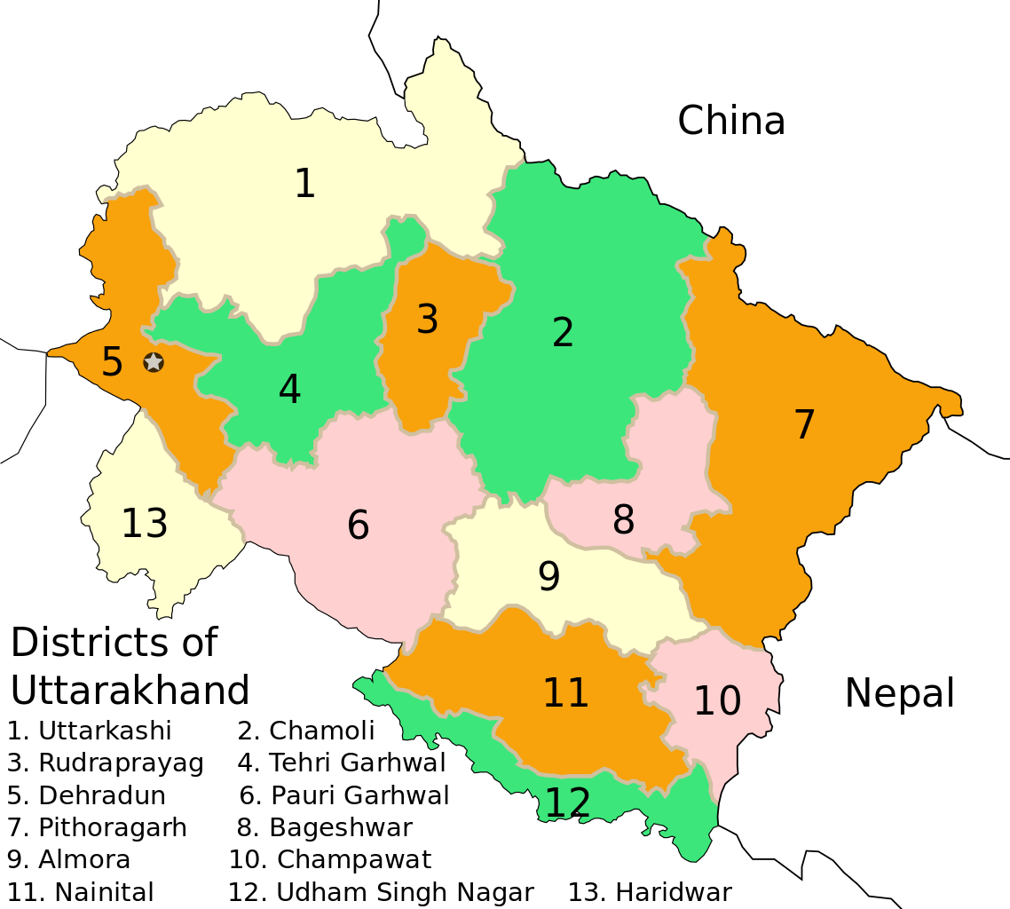
English: Based on File:Uttarakhand_locator_map.svg |
| તારીખ | |
| સ્રોત |
This file was derived from: Uttarakhand locator map.svg |
| લેખક |
|
| અન્ય આવૃત્તિઓ |
[]
|


પરવાના
| હું, આ રચનાઓ પ્રકાશન અધિકાર ધારક, આ રચનાને public domain પર પ્રકાશિત કરું છું. આ સમગ્ર વિશ્વમઆં કાર્યરત રહેશે. અમુક દેશોમાં કાયદેસર રીતે તે શક્ય નથી, જો તેમ હોય તો : કો કોઈને પણ કોઈપણ વપરાશ, કોઇ પણ શરત વગર, માટે આ રચના વાપરવાની છૂટ આપું છું સિવાયકે તે શરતો કાયદેસર જરૂરી હોય. |
આ ફાઈલ વપરાશની પરવાનગી :Creative Commons Attribution 3.0 Unported license.
આરોપણ: Mkeranat
- તમે મુક્ત છો:
- વહેંચવા – નકલ કરવા, વિતરણ કરવા અને રચનાઓ મોકલવા
- રીમિક્સ કરવા કે મઠારવા – રચના અપનાવવા
- નીચેની શરત હેઠળ:
- આરોપણ – તમારે આ રચનાનો ઉપયોગ કરવા માટે લેખક કે પ્રકાશન અધિકાર ધારકની યોગ્ય માહિતી, પરવાનગી (લાયસન્સ)ની કડી અને તેમાં ફેરફાર કર્યો હોય તો તેનો ઉલ્લેખ કરવો જ પડશે. તમે આ સત્તા અનુસાર જ આ રચનાનો પ્રયોગ થવો જોઈએ, પણ તેઓ તમને અથવા તમારા ઉપયોગ સાથે સંમત થાય છે તે રીતે નહીં.

|
આ રચનાની નકલ કરવા, વિતરણ અને સુધારો કરવા માટે GNU Free Documentation License, આવૃત્તિ 1.2 કે અન્ય આગળની આવૃત્તિ Free Software Foundation હેઠળ પરવાનગી છે; જેમાં કોઈ Invariant Sections, no Front-Cover Texts, and no Back-Cover Texts નથી. આ પરવાનાની પ્રત GNU Free Documentation License વિભાગમાં છે. |
ફાઇલનો ઇતિહાસ
તારીખ/સમય ઉપર ક્લિક કરવાથી તે સમયે ફાઇલ કેવી હતી તે જોવા મળશે.
| તારીખ/સમય | લઘુચિત્ર | પરિમાણો | સભ્ય | ટિપ્પણી | |
|---|---|---|---|---|---|
| વર્તમાન | ૧૯:૨૩, ૧૬ જાન્યુઆરી ૨૦૦૯ | | ૧,૨૫૦ × ૧,૧૨૫ (૧૪૫ KB) | GDibyendu | {{Information |Description=District borders with color d0c0a0 as prescribed in WP India cartography dept in en wikipedia |Source=based on previous version only |Date=2009-01-16 |Author=GDibyendu |Permission= |other_versions= }} |
| ૦૦:૨૩, ૧૬ જાન્યુઆરી ૨૦૦૯ |  | ૧,૨૫૦ × ૧,૧૨૫ (૧૪૫ KB) | GDibyendu | {{Information |Description={{en|1=Based on File:Uttarakhand_locator_map.svg}} |Source=Own work by uploader |Author=GDibyendu |Date=2009-01-16 |Permission= |other_versions= }} <!--{{ImageUpload|full}}--> |
ફાઇલનો વપરાશ
આ ફાઇલ માં 14 નીચેનાં પાનાઓ વપરાયેલાં છે:
ફાઇલનો વ્યાપક ઉપયોગ
નીચેની બીજી વિકિઓ આ ફાઈલ વાપરે છે:
- en.wikipedia.org પર વપરાશ
- eu.wikipedia.org પર વપરાશ
- fr.wikipedia.org પર વપરાશ
- hi.wikipedia.org પર વપરાશ
- hr.wikipedia.org પર વપરાશ
- id.wikipedia.org પર વપરાશ
- ml.wikipedia.org પર વપરાશ
- mr.wikipedia.org પર વપરાશ
- ne.wikipedia.org પર વપરાશ
- new.wikipedia.org પર વપરાશ
- pl.wikipedia.org પર વપરાશ
- ru.wikipedia.org પર વપરાશ
- sat.wikipedia.org પર વપરાશ
- sa.wikipedia.org પર વપરાશ
- simple.wikipedia.org પર વપરાશ
- ta.wikipedia.org પર વપરાશ
- te.wikipedia.org પર વપરાશ
- uk.wikipedia.org પર વપરાશ
- ur.wikipedia.org પર વપરાશ
- zh.wikipedia.org પર વપરાશ