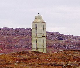
કોલા હોલ

કોલા હોલ કે કોલાનું ઉંડું કાણું (Kola Superdeep Borehole (રશિયન ભાષા: Кольская сверхглубокая скважина)) એ ભૂતપૂર્વ યુ.એસ.એસ.આર.ની 'વૈજ્ઞાનિક શારકામ પરિયોજના'નું પરીણામ છે. આ પરિયોજના પૃથ્વીનાં પોપડામાં શક્ય તેટલે ઉંડે સુધી શારકામ (Drilling) કરવાનો પ્રયાસ હતો. શારકામ ૨૪ મે ૧૯૭૦નાં રોજ,'કોલા પ્રાયદ્વિપ' પર શરૂ કરાયું હતું,તે માટે ઉરલમેશ-૪ઇ (Uralmash-4E), અને પછીથી ઉરલમેશ-૧૫૦૦૦ (Uralmash-15000) શ્રેણીની શારડીઓ (drilling rig)નો ઉપયોગ કરાયો. મુખ્ય હોલમાંથી પ્રશાખારૂપે અન્ય ઘણા હોલ (બોર) કરાયા. ઉંડામાં ઉંડો બોર, 'એસ.જી-૩', ૧૯૮૯ માં ૧૨,૨૬૧ મીટર (૪૦,૨૩૦ ફીટ) એ પહોંચ્યો, અને તે ઉંડામાં ઉંડો શારકામ કરાયેલ બોર બની રહ્યો.[૧] શારકામ કરાયેલો લાંબામાં લાંબો બોર ૧૨,૨૯૦ મીટર (૪૦,૩૦૦ ફીટ)નો મિર્સ્ક તેલકુવો 'બીડી-૦૪એ',અલ-શાહિન ક્ષેત્ર,કતારનો છે.[૨]
ખોદકામ
[ફેરફાર કરો]The initial target depth was set at ૧૫,૦૦૦ મીટર (૪૯,૦૦૦ ફીટ). On 6 June 1979, the world depth record held by the Bertha Rogers hole in Washita County, Oklahoma at ૯,૫૮૩ મીટર (૩૧,૪૪૦ ફીટ)[૩] was broken. In 1983, the drill passed ૧૨,૦૦૦ મીટર (૩૯,૦૦૦ ફીટ), and drilling was stopped for about a year to celebrate the event.[૪] This idle period may have contributed to a break-down on 27 September 1984: after drilling to ૧૨,૦૬૬ મીટર (૩૯,૫૯૦ ફીટ), a ૫,૦૦૦ મીટર (૧૬,૦૦૦ ફીટ) section of drillpipe twisted off and was left in the hole. Drilling was later restarted from ૭,૦૦૦ મીટર (૨૩,૦૦૦ ફીટ).[૪] The hole reached ૧૨,૨૬૨ મીટર (૪૦,૨૩૦ ફીટ) in 1989. In that year the hole depth was expected to reach ૧૩,૫૦૦ મીટર (૪૪,૦૦૦ ફીટ) by the end of 1990 and ૧૫,૦૦૦ મીટર (૪૯,૦૦૦ ફીટ) by 1993.[૫] However, due to higher than expected temperatures at this depth and location, ૧૮૦°સે. (૩૫૬°ફે) instead of expected ૧૦૦°સે (૨૧૨°ફે), drilling deeper was deemed unfeasible and the drilling was stopped in 1992.[૪] With the expected further increase in temperature with increasing depth, drilling to ૧૫,૦૦૦ મીટર (૪૯,૦૦૦ ફીટ) would have meant working at a projected ૩૦૦°સે (૫૭૦°ફે), at which the drill bit would no longer work.
સંશોધન
[ફેરફાર કરો]The Kola borehole penetrated about a third through the Baltic continental crust, presumed to be around ૩૫ કિ.મી. (૨૨ માઇલ), exposing rocks 2.7 billion years old at the bottom.[સંદર્ભ આપો]The project has been a site of extensive geophysical studies. The stated areas of study were the deep structure of the Baltic Shield; seismic discontinuities and the thermal regime in the Earth's crust; the physical and chemical composition of the deep crust and the transition from upper to lower crust; lithospheric geophysics; and to create and develop technologies for deep geophysical study.
To scientists, one of the more fascinating findings to emerge from this well is that the change in seismic velocities was not found at a boundary marking Jeffreys' hypothetical transition from granite to basalt; it was at the bottom of a layer of metamorphic rock that extended from about 5 to 10 kilometers beneath the surface. The rock there had been thoroughly fractured and was saturated with water, which was surprising. This water, unlike surface water, must have come from deep-crust minerals and had been unable to reach the surface because of a layer of impermeable rock.[૬]
Another unexpected discovery was the large quantity of hydrogen gas, with the mud flowing out of the hole described as "boiling" with hydrogen.[૭]
વર્તમાન સ્થીતિ
[ફેરફાર કરો]
The site is currently controlled by the State Scientific Enterprise on Superdeep Drilling and Complex Investigations in the Earth's Interior (GNPP Nedra) as the Deep Geolaboratory. As of 2003[update], the deepest active bore, SG-5, is ૮,૫૭૮ મીટર (૨૮,૧૪૦ ફીટ) and with a ૨૧૪ મી.મી. (૮.૪ ઇંચ) diameter.[સંદર્ભ આપો]
અન્ય પરિયોજનાઓ
[ફેરફાર કરો]The United States embarked on a similar project in 1957, dubbed Project Mohole, which was intended to penetrate the shallow crust under the Pacific Ocean off Mexico. However, after some initial drilling, the project was abandoned in 1966 due to lack of funding. This "failure" inspired great successes of the Deep Sea Drilling Project, Ocean Drilling Program, and the present Integrated Ocean Drilling Program.
સંદર્ભ
[ફેરફાર કરો]ગ્રંથસુચી
[ફેરફાર કરો]- Fuchs, K., Kozlovsky, E.A., Krivtsov, A.I., and Zoback, M.D. (Eds.) (1990) Super-Deep Continental Drilling and Deep Geophysical Sounding. Springer Verlag, Berlin, 436 pp.
- Kozlovsky, Ye.A. (Ed.) (1987) The Superdeep Well of the Kola Peninsula. Springer Verlag, Berlin, 558 pp.
નોંધ
[ફેરફાર કરો]- ↑ "Kola Superdeep Borehole (KSDB)". ICDP. મૂળ માંથી 2010-02-01 પર સંગ્રહિત. મેળવેલ 2009-04-08.
- ↑ "Maersk Oil finished Drilling (BD-04A) well at Al-Shaheen field, Qatar". Gulf Oil & Gas Marketplace. 23 May 2008. મેળવેલ 2009-04-08.
- ↑ "The KTB Borehole—Germany's Superdeep Telescope into the Earth's Crust" (PDF). Oilfield Review. મૂળ (PDF) માંથી 2006-04-28 પર સંગ્રહિત. મેળવેલ 2009-04-08.
- ↑ ૪.૦ ૪.૧ ૪.૨ A. Osadchy (no. 5, 2002). "Legendary Kola Superdeep". Наука и жизнь (Journal of Science and Life) (Russianમાં). મેળવેલ 2009-04-08. Check date values in:
|date=(મદદ)CS1 maint: unrecognized language (link) - ↑ Kola Superdeep is in the Guinness Book of World Records, Zemlya i Vselennaya, 1989, no. 3, p.9 ઢાંચો:Ru icon
- ↑ Alan Bellows (5 March 2007). "The Deepest Hole". Damn Interesting. મેળવેલ 2009-04-08.
- ↑ G.J. MacDonald (1988). A. Bodén and K.G. Eriksson (સંપાદક). Major Questions About Deep Continental Structures. Berlin: Springer-Verlag. પૃષ્ઠ 28–48. ISBN 3540189955. Cite uses deprecated parameter
|booktitle=(મદદ)
બાહ્ય કડીઓ
[ફેરફાર કરો]- અધિકૃત કોલા હોલ વેબસાઇટ (રશિયન ભાષામાં)
- વિશ્વનો ઉંડો હોલ (બોર) - અલાસ્કા વિજ્ઞાન મંચ - જુલાઇ ૧૯૮૫ સંગ્રહિત ૨૦૧૪-૦૫-૩૧ ના રોજ વેબેક મશિન
- કેસિનો, આદમ (૨૦૦૩). "Depth of the Deepest Drilling". The Physics Factbook.
- ઉંડો હોલ (બોર) જૂન ૨૦ ૨૦૦૬
