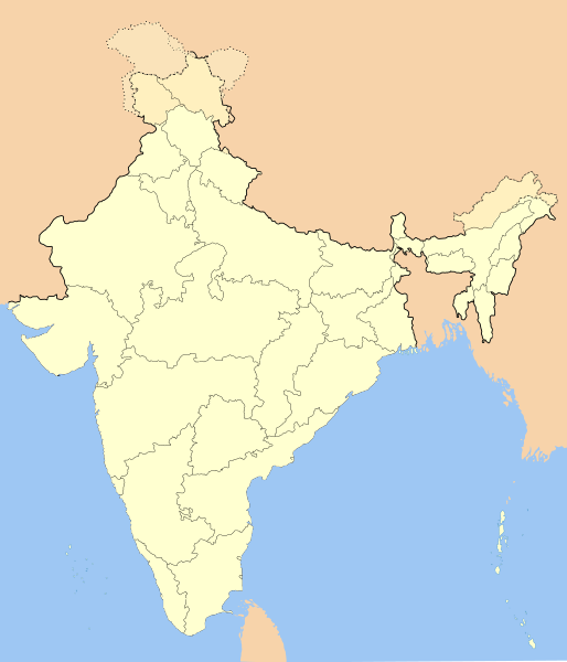
ચિત્ર:India-locator-map-blank.svg

Size of this PNG preview of this SVG file: ૫૧૪ × ૬૦૦ પિક્સેલ. અન્ય આવર્તનો: ૨૦૬ × ૨૪૦ પિક્સેલ | ૪૧૧ × ૪૮૦ પિક્સેલ | ૬૫૮ × ૭૬૮ પિક્સેલ | ૮૭૭ × ૧,૦૨૪ પિક્સેલ | ૧,૭૫૫ × ૨,૦૪૮ પિક્સેલ | ૧,૪૮૬ × ૧,૭૩૪ પિક્સેલ.
મૂળભુત ફાઇલ (SVG ફાઇલ, માત્ર ૧,૪૮૬ × ૧,૭૩૪ પીક્સલ, ફાઇલનું કદ: ૨૫૨ KB)
ફાઇલનો ઇતિહાસ
તારીખ/સમય ઉપર ક્લિક કરવાથી તે સમયે ફાઇલ કેવી હતી તે જોવા મળશે.
| તારીખ/સમય | લઘુચિત્ર | પરિમાણો | સભ્ય | ટિપ્પણી | |
|---|---|---|---|---|---|
| વર્તમાન | ૧૯:૩૧, ૧૪ ઓક્ટોબર ૨૦૨૦ |  | ૧,૪૮૬ × ૧,૭૩૪ (૨૫૨ KB) | NordNordWest | upd Telangana/Andhra Pradesh |
| ૨૩:૧૮, ૨૫ જુલાઇ ૨૦૨૦ |  | ૧,૪૮૬ × ૧,૭૩૪ (૨૫૨ KB) | NordNordWest | Jammu and Kashmir/Ladakh | |
| ૦૭:૧૨, ૧ એપ્રિલ ૨૦૧૭ |  | ૧,૪૮૬ × ૧,૭૩૪ (૩૩૭ KB) | Utcursch | Moved Telangana to states layer | |
| ૧૯:૩૮, ૨૯ જાન્યુઆરી ૨૦૧૬ |  | ૧,૪૮૬ × ૧,૭૩૪ (૩૭૯ KB) | Csyogi | Telangana update | |
| ૨૧:૦૬, ૧૬ મે ૨૦૦૬ |  | ૧,૪૮૬ × ૧,૭૩૪ (૪૨૧ KB) | Nichalp | Siachen edits | |
| ૧૮:૧૯, ૧૩ મે ૨૦૦૬ |  | ૧,૪૮૬ × ૧,૭૩૪ (૪૨૪ KB) | Nichalp | Siachen correction | |
| ૧૮:૧૩, ૧૩ મે ૨૦૦૬ |  | ૧,૪૮૬ × ૧,૭૩૪ (૪૨૨ KB) | Nichalp | border changes | |
| ૧૧:૨૩, ૯ મે ૨૦૦૬ |  | ૧,૪૮૬ × ૧,૭૩૪ (૪૨૧ KB) | Nichalp | Updates as suggested in FPC | |
| ૧૩:૧૮, ૭ મે ૨૦૦૬ |  | ૧,૪૮૬ × ૧,૭૩૪ (૪૨૧ KB) | Nichalp | Version 2; added some additional disputed areas in the Western sector | |
| ૨૩:૫૭, ૬ મે ૨૦૦૬ |  | ૧,૪૮૬ × ૧,૭૩૪ (૪૧૬ KB) | Nichalp | Blank locator map of India SVG Map drawn by me, ~~~~ category:Maps of India |
ફાઇલનો વપરાશ
આ ફાઇલ માં 20 નીચેનાં પાનાઓ વપરાયેલાં છે:
ફાઇલનો વ્યાપક ઉપયોગ
નીચેની બીજી વિકિઓ આ ફાઈલ વાપરે છે:
- as.wikipedia.org પર વપરાશ
- as.wikiquote.org પર વપરાશ
- awa.wikipedia.org પર વપરાશ
- खाँचा:ज्ञानसन्दूक भारत कय क्षेत्र
- भारत कय राज्य
- भारत कय संघ राज्यक्षेत्र
- खाँचा:India States and Territories Labelled Map
- खाँचा:Infobox Indian Jurisdiction
- खाँचा:Infobox Indian Jurisdiction/Examples/city
- खाँचा:Infobox Indian Jurisdiction/Examples/district
- खाँचा:Infobox Indian Jurisdiction/Examples/neighbourhood
- खाँचा:Infobox Indian Jurisdiction/Examples/protected area
- खाँचा:Infobox Indian Jurisdiction/Examples/state
- खाँचा:Infobox Indian Jurisdiction/Examples/suburb
- खाँचा:Infobox Indian Jurisdiction/Examples/town
- खाँचा:Infobox Indian Jurisdiction/Examples/village
- खाँचा:Infobox Indian Jurisdiction/Sandbox
- खाँचा:Infobox Indian Jurisdiction/Sandbox/doc
- खाँचा:Infobox Indian Jurisdiction/doc
- खाँचा:ज्ञानसन्दूक भारत कय क्षेत्र/doc
- सीधी
- ban.wikipedia.org પર વપરાશ
- bn.wikipedia.org પર વપરાશ
- bpy.wikipedia.org પર વપરાશ
આ ફાઇલના વધુ વૈશ્વિક વપરાશ જુઓ.


